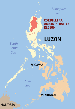
Cordillera Administrative Region
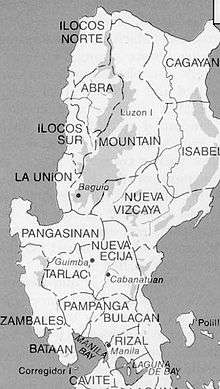
Cordillera Administrative Region, also known as Cordillera Region (Ilocano: Rehion/Deppaar Administratibo ti Kordiliera; Tagalog: Rehiyong Pampangasiwaan ng Cordillera), designated as CAR, is an administrative region in the Philippines, situated within the island of Luzon. The only landlocked region in the insular country, it is bordered by the Ilocos Region to west and southwest, and by the Cagayan Valley Region to the north, east, and southeast. It is the least populous region in the Philippines, with a population less than that of the City of Manila.
Cordillera Administrative Region CAR | |
|---|---|
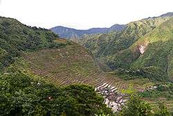 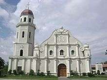 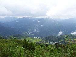 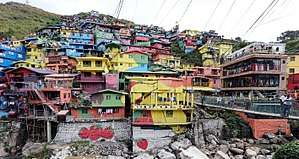 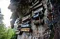 From top, left to right: Batad Rice Terraces; Tayum Church; Lubuagan, Kalinga; Colors of StoBoSa, Hanging coffins of Sagada | |
 Flag  Seal | |
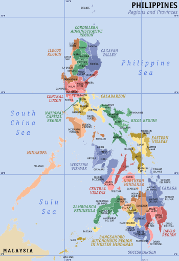
 Location in the Philippines | |
| Coordinates: 17°10′N 121°10′E | |
| Country | |
| Island group | Luzon |
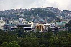
| Regional center | Baguio |
| Area | |
| • Total | 19,422.03 km2 (7,498.89 sq mi) |
| Population (2015 census)[1] | |
| • Total | 1,722,006 |
| • Density | 89/km2 (230/sq mi) |
| Time zone | UTC+8 (PST) |
| ISO 3166 code | PH-15 |
| Provinces | |
| Cities | 2
|
| Municipalities | 75 |
| Barangays | 1,176 |
| Cong. districts | 7 |
| Languages | |
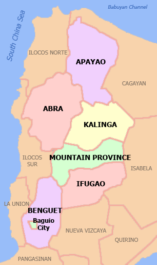
The region comprises six landlocked provinces: Abra, Apayao, Benguet, Ifugao, Kalinga and Mountain Province. The regional center is the highly urbanized city of Baguio.
The landlocked region, officially created on July 15, 1987,[2] covers most of the Cordillera Central mountains of Luzon, and is home to numerous ethnic peoples. The landlocked Nueva Vizcaya province has a majority-Igorot population, but was placed by the American colonial government in the Cagayan Valley region instead during the early 20th century.
History
Background
Colonial Era
During the Spanish occupation of the Philippines, Christianization and eventual subjugation of the mountain region proved difficult for the Spanish colonial government.[3] Several comandancias were established by the Spanish colonial government in strategic areas of the mountain region. Among them were Amburayan, Cabugaoan, Kayapa, Quiangan, Itaves, Apayaos, Lepanto, Benguet, Bontoc, Banaue, and Tiagan.[4][5][6]
On August 18, 1908 during the American regime, Mountain Province was established by the Philippine Commission with the enactment of Act No. 1876. Ifugao, which was part of Nueva Vizcaya province,[7] and the former Spanish comandancias of Amburayan, Apayao, Benguet, Bontoc, Kalinga and Lepanto, were annexed to the newly created province as sub-provinces.[8][9] Amburayan was later abolished in 1920 and its corresponding territories were transferred to the provinces of Ilocos Sur and La Union. Lepanto was also reduced in size and its towns were integrated into the sub-provinces of Bontoc and Benguet, and to the province of Ilocos Sur.[3][10][11]
After Philippine Independence
On June 18, 1966, Republic Act No. 4695 was enacted to split Mountain Province and create four separate and independent provinces namely Benguet, Ifugao, Kalinga-Apayao, and Mountain Province.[12][13] Ifugao and Kalinga-Apayao were placed under the jurisdiction of the Cagayan Valley region,[14] with Benguet and Mountain Province placed under the Ilocos Region.
Cordilleran history during Martial law
After the declaration of Martial law by Ferdinand Marcos in 1972, the region became the focus of militarization as a result of local objections to the government's push for the Chico River Dam Project near Sadanga, Mountain Province and Tinglayan, Kalinga.[15][16][17] Frustrated by the project delays caused by the opposition, Ferdinand Marcos issued Presidential Decree no. 848 in December 1975, constituting the municipalities of Lubuagan, Tinglayan, Tanudan, and Pasil into a "Kalinga Special Development Region" (KSDR),[18] in an effort to neutralize opposition to the Chico IV dam.[17]
Empowered by Martial Law to conduct warrantless arrests, the 60th PC Brigade had arrested at least 150 locals by April 1977, accusing them of supposed subversion and of obstructing government projects, and various other offenses such as boycotting the October 1976 Constitutional Referendum. Individuals arrested included tribal papangat (leaders/elders), young couples, and in at least one case, a 12-year-old child.[17](p9) By December 1978, parts of the Chico IV area had been declared "free fire zones", no-man's-land areas where the army could freely fire on any animals or permit-less humans at will.[17]
On April 24, 1980, Marcos-controlled military forces assassinated Macli-ing Dulag a pangat (leader) of the Butbut tribe of Kalinga.[19] The assassination became a watershed moment, marking the first time the mainstream Philippine press could be openly critical against Marcos and the Military, and building up a sense of Igorot identity which eventually led to cordillera autonomy.[20]
Creation of the region
On July 15, 1987, President Corazon C. Aquino issued Executive Order 220 which created the Cordillera Administrative Region. The provinces of Abra, Benguet and Mountain Province (of the Ilocos Region), and Ifugao and Kalinga-Apayao (of the Cagayan Valley) were annexed as part of the newly created region. Nueva Vizcaya was not included in the region despite having an Igorot majority at the time.[2][21]
Modern history
On February 14, 1995, Kalinga-Apayao, one of the five provinces of the region was split into two separate and independent provinces of Apayao and Kalinga with the enactment of Republic Act No. 7878.[22][23]
Several attempts at legalizing autonomy in the Cordillera region have failed in two separate plebiscites.[24][25] An affirmative vote for the law on regional autonomy is a precondition by the 1987 Philippine Constitution to give the region autonomy in self-governance much like the Autonomous Region of Muslim Mindanao (now the BARMM) in southern Philippines. The first law Republic Act No. 6766, took effect on October 23, 1989[26] but failed to muster a majority vote in the plebiscite on January 30, 1990.[24][25] The second law, Republic Act No. 8438 passed by Congress of the Philippines on December 22, 1997,[27] also failed to pass the approval of the Cordillera peoples in a region-wide plebiscite on March 7, 1998.[24][25]
At present, a third organic act of the Cordillera is in the offing supported by the Cordillera Regional Development Council.
Recent events
In September 2000, the municipal council of Itogon, Benguet, withdrew support for the San Roque Dam project. The project had met a lot of resistance, because of the reported failure of its proponents to update its Environmental Certificate of Compliance (ECC) and to submit a watershed management plan required for a project of that magnitude. The San Roque Dam was to become one of the biggest dams in the world and would threaten the living environment of the Igorot.
The Cordillera Peoples Alliance (CPA), an indigenous rights organization in the region, in co-operation with other organizations, had highly resisted this project and thus booked a little victory. However, in May 2001, president Arroyo declared that the San Roque Dam project would continue anyway because it had already started and therefore was difficult to stop. At the same time she promised to not sacrifice the environment, to resettle the people who will lose their houses, to compensate other people, and to initiate no other large-scale irrigation projects in the future.
In December 2000, the Supreme Court of the Philippines dismissed a petition that questioned the constitutional legality of the Indigenous Peoples Rights Act (IPRA), and act which came into existence in 1997 giving the peoples of the Cordillera decisive influence over the establishment of foreign mining companies. In this act, ownership over the lands was regarded as communal, rather than individual and thus coincided more with the view on ownership of the Igorot. The IPRA was totally different in tone than the 1995 Mining Code.
Without consultation from the people of the Cordilleras, the Mining Code gave companies the freedom to devastate tribal lands, allowed 100% foreign ownership, and gave companies the right to displace and resettle people within their concessionary areas. Some influential people filed a lawsuit with the Supreme Court against the IPRA, because it contradicted with the Mining Code and would therefore be unlawful. The petition was dismissed in a 7–7 vote by the Supreme Court.
A bill creating an autonomous Cordillera was filed in Congress in 2014, but it was not backed by strategic politicians in the region due to lack of support from the national government. However, in 2017, all provincial congressmen within the CAR jointly filed a new Bill creating an autonomous Cordillera, the first time in three decades where all provincial district representatives called in unison for autonomy. The move was made due to the election win of President Duterte, who publicly supported the creation of an autonomous Cordillera. However, questions lingered on the issue of Nueva Vizcaya's exclusion from the proposed region, despite being culturally and geographically part of the Cordilleras, leaving Nueva Vizcaya Igorots left out from the proposal.[28][29]
Geography
The region is the only landlocked region in the Philippines, bounded on the northeast and east by the Cagayan Valley, and on the southwest and west by the Ilocos Region.
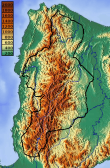
The region is primarily mountainous, positioned in the Cordillera Central mountain range, which includes Mount Pulag, the highest mountain in Luzon.[30]
Within the region are several streams and rivers including the Chico River, which is a tributary of the Cagayan River. Other major rivers include[31][32]
Administrative divisions
Cordillera Administrative Region is politically subdivided into 6 provinces. It has 2 cities; the highly urbanized city of Baguio, and the component city of Tabuk. There are 1,176 barangays in the region. Geographically, the western half of Nueva Viscaya is part of the main Cordilleras, while its eastern half is part of the Caraballos, the meeting point of the Cordilleras and the Sierra Madre. There have been moves to reunify Nueva Vizcaya with the Cordilleras, however, no such legislation has yet been introduced in Congress.
| Province or HUC | Capital | Population (2015)[1] | Area[33] | Density | Cities | Muni. | Barangay | |||||
|---|---|---|---|---|---|---|---|---|---|---|---|---|
| km2 | sq mi | /km2 | /sq mi | |||||||||
| Abra | Bangued | 14.0% | 241,160 | 4,165.25 | 1,608.21 | 58 | 150 | 0 | 27 | 303 | ||
| Apayao | Luna | 6.9% | 119,184 | 4,413.35 | 1,704.00 | 27 | 70 | 0 | 7 | 133 | ||
| Benguet | La Trinidad | 25.9% | 446,224 | 2,769.08 | 1,069.15 | 160 | 410 | 1 | 13 | 140 | ||
| Ifugao | Lagawe | 11.8% | 202,802 | 2,628.21 | 1,014.76 | 77 | 200 | 0 | 11 | 175 | ||
| Kalinga | Tabuk | 12.4% | 212,680 | 3,231.25 | 1,247.59 | 66 | 170 | 1 | 7 | 152 | ||
| Mountain Province | Bontoc | 9.0% | 154,590 | 2,157.38 | 832.97 | 72 | 190 | 0 | 10 | 144 | ||
| Baguio | † | — | 20.1% | 345,366 | 57.51 | 22.20 | 6,000 | 16,000 | — | — | 129 | |
| Total | 1,722,006 | 19,422.03 | 7,498.89 | 89 | 230 | 2 | 75 | 1,176 | ||||
|
† Baguio is a highly-urbanized city; figures are excluded from Benguet. | ||||||||||||
- † Regional center
| City/Municipality | Population (2015)[1] | Area[34] | Density | Class | Income class | Province | ||
|---|---|---|---|---|---|---|---|---|
| Aguinaldo | 19,408 | 538.05 | 207.74 | 36 | 93 | Municipality | 2nd | Ifugao |
| Alfonso Lista | 32,119 | 347.46 | 134.16 | 92 | 240 | Municipality | 3rd | Ifugao |
| Asipulo | 15,261 | 182.87 | 70.61 | 83 | 210 | Municipality | 5th | Ifugao |
| Atok | 19,668 | 214.99 | 83.01 | 91 | 240 | Municipality | 4th | Benguet |
| † Baguio City | 345,366 | 57.51 | 22.20 | 6,000 | 16,000 | Highly Urbanized City | 1st | Benguet |
| Bakun | 15,357 | 286.91 | 110.78 | 54 | 140 | Municipality | 3rd | Benguet |
| Balbalan | 12,195 | 542.69 | 209.53 | 22 | 57 | Municipality | 3rd | Kalinga |
| Banaue | 21,837 | 191.20 | 73.82 | 110 | 280 | Municipality | 4th | Ifugao |
| Bangued | 48,163 | 105.70 | 40.81 | 460 | 1,200 | Municipality | 1st | Abra |
| Barlig | 4,819 | 228.64 | 88.28 | 21 | 54 | Municipality | 5th | Mountain Province |
| Bauko | 31,065 | 153.00 | 59.07 | 200 | 520 | Municipality | 4th | Mountain Province |
| Besao | 7,040 | 173.62 | 67.04 | 41 | 110 | Municipality | 5th | Mountain Province |
| Bokod | 13,756 | 274.96 | 106.16 | 50 | 130 | Municipality | 4th | Benguet |
| Boliney | 3,573 | 216.92 | 83.75 | 16 | 41 | Municipality | 5th | Abra |
| Bontoc | 24,643 | 396.10 | 152.94 | 62 | 160 | Municipality | 2nd | Mountain Province |
| Bucay | 17,115 | 102.16 | 39.44 | 170 | 440 | Municipality | 5th | Abra |
| Bucloc | 2,501 | 63.77 | 24.62 | 39 | 100 | Municipality | 6th | Abra |
| Buguias | 43,627 | 175.88 | 67.91 | 250 | 650 | Municipality | 3rd | Benguet |
| Calanasan | 12,604 | 1,256.15 | 485.00 | 10 | 26 | Municipality | 1st | Apayao |
| Conner | 26,051 | 694.30 | 268.07 | 38 | 98 | Municipality | 2nd | Apayao |
| Daguioman | 2,088 | 114.37 | 44.16 | 18 | 47 | Municipality | 5th | Abra |
| Danglas | 4,192 | 156.02 | 60.24 | 27 | 70 | Municipality | 5th | Abra |
| Dolores | 11,315 | 47.45 | 18.32 | 240 | 620 | Municipality | 5th | Abra |
| Flora | 17,391 | 324.40 | 125.25 | 54 | 140 | Municipality | 3rd | Apayao |
| Hingyon | 9,227 | 62.02 | 23.95 | 150 | 390 | Municipality | 5th | Ifugao |
| Hungduan | 9,400 | 260.30 | 100.50 | 36 | 93 | Municipality | 4th | Ifugao |
| Itogon | 59,820 | 449.73 | 173.64 | 130 | 340 | Municipality | 1st | Benguet |
| Kabayan | 15,260 | 242.69 | 93.70 | 63 | 160 | Municipality | 4th | Benguet |
| Kabugao | 15,537 | 935.12 | 361.05 | 17 | 44 | Municipality | 1st | Apayao |
| Kapangan | 19,361 | 164.39 | 63.47 | 120 | 310 | Municipality | 4th | Benguet |
| Kiangan | 17,048 | 200.00 | 77.22 | 85 | 220 | Municipality | 4th | Ifugao |
| Kibungan | 17,292 | 254.86 | 98.40 | 68 | 180 | Municipality | 4th | Benguet |
| La Paz | 15,437 | 51.41 | 19.85 | 300 | 780 | Municipality | 5th | Abra |
| La Trinidad | 129,133 | 70.04 | 27.04 | 1,800 | 4,700 | Municipality | 1st | Benguet |
| Lacub | 3,403 | 295.30 | 114.02 | 12 | 31 | Municipality | 5th | Abra |
| Lagangilang | 14,255 | 101.44 | 39.17 | 140 | 360 | Municipality | 5th | Abra |
| Lagawe | 19,333 | 208.91 | 80.66 | 93 | 240 | Municipality | 4th | Ifugao |
| Lagayan | 4,499 | 215.97 | 83.39 | 21 | 54 | Municipality | 5th | Abra |
| Lamut | 25,279 | 159.65 | 61.64 | 160 | 410 | Municipality | 4th | Ifugao |
| Langiden | 3,198 | 116.29 | 44.90 | 28 | 73 | Municipality | 5th | Abra |
| Licuan-Baay | 4,689 | 256.42 | 99.00 | 18 | 47 | Municipality | 5th | Abra |
| Luba | 6,339 | 148.27 | 57.25 | 43 | 110 | Municipality | 5th | Abra |
| Lubuagan | 8,733 | 234.20 | 90.43 | 37 | 96 | Municipality | 4th | Kalinga |
| Luna | 19,063 | 606.04 | 233.99 | 31 | 80 | Municipality | 2nd | Apayao |
| Malibcong | 3,428 | 283.17 | 109.33 | 12 | 31 | Municipality | 5th | Abra |
| Manabo | 10,761 | 110.95 | 42.84 | 97 | 250 | Municipality | 5th | Abra |
| Mankayan | 35,953 | 130.48 | 50.38 | 280 | 730 | Municipality | 1st | Benguet |
| Mayoyao | 17,331 | 238.05 | 91.91 | 73 | 190 | Municipality | 4th | Ifugao |
| Natonin | 10,272 | 252.00 | 97.30 | 41 | 110 | Municipality | 4th | Mountain Province |
| Paracelis | 28,121 | 570.16 | 220.14 | 49 | 130 | Municipality | 2nd | Mountain Province |
| Pasil | 9,644 | 189.00 | 72.97 | 51 | 130 | Municipality | 5th | Kalinga |
| Peñarrubia | 6,640 | 38.29 | 14.78 | 170 | 440 | Municipality | 6th | Abra |
| Pidigan | 12,185 | 49.15 | 18.98 | 250 | 650 | Municipality | 5th | Abra |
| Pilar | 10,223 | 66.10 | 25.52 | 150 | 390 | Municipality | 5th | Abra |
| Pinukpuk | 32,026 | 743.56 | 287.09 | 43 | 110 | Municipality | 1st | Kalinga |
| Pudtol | 14,925 | 401.02 | 154.83 | 37 | 96 | Municipality | 4th | Apayao |
| Rizal | 17,038 | 231.00 | 89.19 | 74 | 190 | Municipality | 4th | Kalinga |
| Sabangan | 9,315 | 72.04 | 27.81 | 130 | 340 | Municipality | 5th | Mountain Province |
| Sablan | 11,457 | 105.63 | 40.78 | 110 | 280 | Municipality | 5th | Benguet |
| Sadanga | 8,799 | 83.30 | 32.16 | 110 | 280 | Municipality | 5th | Mountain Province |
| Sallapadan | 6,622 | 128.62 | 49.66 | 51 | 130 | Municipality | 5th | Abra |
| San Isidro | 4,574 | 48.07 | 18.56 | 95 | 250 | Municipality | 5th | Abra |
| San Juan | 9,867 | 64.08 | 24.74 | 150 | 390 | Municipality | 5th | Abra |
| San Quintin | 5,438 | 66.59 | 25.71 | 82 | 210 | Municipality | 5th | Abra |
| Santa Marcela | 13,613 | 196.32 | 75.80 | 69 | 180 | Municipality | 4th | Apayao |
| Tadian | 19,389 | 145.20 | 56.06 | 130 | 340 | Municipality | 4th | Mountain Province |
| Tanudan | 9,534 | 307.55 | 118.75 | 31 | 80 | Municipality | 4th | Kalinga |
| Tayum | 14,467 | 61.14 | 23.61 | 240 | 620 | Municipality | 5th | Abra |
| Tineg | 5,097 | 744.80 | 287.57 | 6.8 | 18 | Municipality | 2nd | Abra |
| Tinglayan | 12,868 | 283.00 | 109.27 | 45 | 120 | Municipality | 4th | Kalinga |
| Tinoc | 16,559 | 239.70 | 92.55 | 69 | 180 | Municipality | 4th | Ifugao |
| Tuba | 47,648 | 295.97 | 114.27 | 160 | 410 | Municipality | 1st | Benguet |
| Tublay | 17,892 | 102.55 | 39.59 | 170 | 440 | Municipality | 5th | Benguet |
| Tubo | 5,699 | 409.87 | 158.25 | 14 | 36 | Municipality | 4th | Abra |
| Villaviciosa | 5,392 | 102.93 | 39.74 | 52 | 130 | Municipality | 5th | Abra |
| Tabuk City | 110,642 | 700.25 | 270.37 | 160 | 410 | Component City | 5th | Kalinga |
Demographics
| Year | Pop. | ±% |
|---|---|---|
| 1990 | 1,146,191 | — |
| 2000 | 1,365,412 | +19.1% |
| 2010 | 1,616,867 | +18.4% |
| 2015 | 1,722,006 | +6.5% |
| Source: Philippine Statistics Authority[35] | ||
Ethnic groups
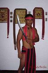
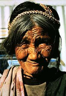
Cordillera is home to many ethnic tribes living on the Cordillera mountain range. They are commonly referred to as the Igorot.
Ethnic people of Abra
The Tingguians are composed of sub-groups known as the Itneg tribes which includes Adasen, Balatok, Banaw, Belwang, Binungan, Gubang, Inlaud, Mabaka, Maeng, Masadiit, and Muyadan or Ammutan.:[36] Their places in Abra are as follows:
- Adasen — Lagayan, Lagangilang, San Juan and Tineg
- Banaw — Daguioman, Malibcong, also found in Balbalan, Kalinga
- Binungan — Baay-Licuan and Lacub
- Balatok — in the villages of Amti, Kilong-olaw, & Danak, all in Boliney
- Belwang — in the village of Dao-angan in Boliney
- Gubang — Malibcong
- Inlaud — Lagangilang and Peñarrubia, in Lumaba village of Villaviciosa, in the villages of Abang and Patoc in Bucay, in Langiden, San Isidro, San Quintin, Danglas (also found in some parts of Nueva Era)
- Mabaka — Lacub and Malibcong
- Maeng — Luba, Tubo and Villaviciosa, (also found in San Emilio, Ilocos Sur, Banayoyo and other towns in Ilocos Sur)
- Masadiit — Sallapadan, Bucloc and in the village of Sapdaan in Manabo, and in barangays Poblacion, Bawiyan, and Dumagas in Boliney
- Ammutan a.k.a. Muyadan tribe — in Manabo
Ethnic people of Apayao
- Isnag tribe — also known as Isneg comprising the sub-groups known as the Ymandaya and Imallod (Isnag refers to the people, while Isneg refers to the dialect). Isnags are found not only in Apayao but also in the eastern section of Ilocos Norte and northwestern portion of Cagayan. Their places of abode in Apayao are as follows:
- Ymandaya (Isnag) — Calanasan (Bayag)
- Imallod (Isnag) — Kabugao, Conner, Pudtol, and some parts of Luna (Macatel)
- Malaweg — Conner
Ethnic People of Ifugao
- Tuwali
- Ayangan
- Kalanguya
- Ifannawer - Banaue
Ethnic people of Kalinga
- Tubog
- Banao
- Tanudan
- Tanudan
- Tongrayan
- Ifutfut: Fugnay, Ngifat, Lacnog, Tabuk
- Iterkaw: Nambaran, Tabuk
- Ifasao: Isla, Appas Tabuk
- Ichananaw: Lacnog, Tabuk
- Itongrayan: Luprupa, Ifunug, Amfato, Damsite, Tabuk
- Isumacher: Sumacher, Filong, Man-ufer, Mallango, Fangad, Madopdop, Lacnog, Ipil, Bayabat, Tannubong, Bulo. Tabuk
- Ylubuagen: Lubuagan
- Ipinukpuk
- Kankana-ey
- Bagbag-o
- Ifontok
- Ilocano
Ethnic people of Mountain Province
Languages
The region has been called "the most diversified ethno-linguistic regionin the Philippines"[30] with the many "sub-dialect variations" of its major languages.[30] This diversity has been attributed to the mountainous topology of the region.[30] However, this did not lead to variations in "cultural development", and the majority of the people share a "similar cultural identity".[30]
|
Religion
Like most other regions of the Philippines, Roman Catholicism is the single largest denomination in this region, however, a slightly lower (around 60–70% of the population) adhere to the faith, while Protestants, mostly Anglicans and Evangelicals forming a large minority at about 20–30% of the population.[38][39] The traditional animist religions maintain a significant presence in the region and are still practiced by the tribal people.
Infrastructure
Roads and Bridges
- Apayao – Ilocos Norte Road – As a lateral road, the highway is a significant element of the Cordillera Roads Improvement Project (CRIP), connecting Northern Cordillera to the Ilocos Region. It traverses Apayao's Kabugao and Calanasan municipalities and turns west to Ilocos Norte's Solsona. This road project was started on January 7, 2013 and will be completed around December 2020.[40]
Culture
The Cordillera region is known for its unique musical instruments including the gangsa kalinga, nose flute, bamboo flute, buzzer, bangibang, tongatong, diwdiw-as, saggeypo, and bamboo zither. It is also known for their danc
Tourism

- Banaue Rice Terraces which is part of the Rice Terraces of the Philippine Cordilleras (World Heritage site)
- Cassamata Hill National Park
- Kabayan Mummies
- Mount Data, Balbalasang-Balbalan National Park
- Mount Pulag, the highest mountain in Luzon at 2,922 metres (9,587 ft) above sea level
- Baguio Sites which includes Burnham Park, Minesview Park, The Mansion, Lion's Head, Camp John Hay Philippine Military Academy, Bell Church, Wright Park, Baguio Garden, and Centermall
Beaches
Due to its landlocked location, the region does not offer any swimmable beach. However, it has easy access to the capital Manila.
References
- Census of Population (2015). "Cordillera Administrative Region (CAR)". Total Population by Province, City, Municipality and Barangay. PSA. Retrieved June 20, 2016.
- "Regional Profile: Cordillera Administrative Region (CAR)". CountrySTAT Philippines. Archived from the original on October 22, 2014. Retrieved September 18, 2014.
- "Mt. Province". VisitMyPhilippines.com The Ultimate Travel Guide for Tourists. Department of Tourism. Retrieved December 23, 2013.
- Keesing, Felix Maxwell; Keesing, Marie Margaret; Keesing, Marie Martin; Institute of Pacific Relations (contributor); International Research Committee (contributor) (1934). Taming Philippine Headhunters: A Study of Government and of Cultural Change in Northern Luzon. Stanford University Press. pp. 67–69. ISBN 9780804721103. Retrieved January 2, 2015.
- "Benguet History". Province of Benguet (official website). Archived from the original on October 19, 2014. Retrieved October 22, 2014.
Benguet was once part of Mountain Province.
- "Historical Background". Provincial Government of Apayao. Archived from the original on January 4, 2015. Retrieved January 3, 2015.
- National Historical Institute (Philippines) [contributor] (1978). Kasaysayan, Volume 3, Issues 1–4 (Digitized by Google on September 26, 2009). National Historical Institute. p. 16. Retrieved January 2, 2015.
(Original file from the University of Michigan)
- Ingles, Raul Rafael (2008). 1908 :The Way it Really was : Historical Journal for the UP Centennial, 1908–2008. Diliman, Quezon City: University of the Philippines Press. pp. 330, 339. ISBN 9715425801. Retrieved January 2, 2015.
- Worcester, Dean C.; Philippine Commission (1908). Seventh Annual Report of the Secretary of the Interior to the Philippine Commission for the Fiscal Year Ended June 30, 1908 (Digitized by Google on November 23, 2005 (Original file from the University of Michigan)). Manila: U.S. Government Printing Office. pp. 17–19. Retrieved January 2, 2015.
(Google Books link
- Philippines. Census Office; Buencamino, Felipe; Villamor, Ignacio (1920). Census of the Philippine Islands Taken Under the Direction of the Philippine Legislature in the Year 1918, Volume 1. Bureau of printing. p. 68.
- "Cordillera Administrative Region History". Cordillera Connection (Blogspot). August 14, 2009. Retrieved October 22, 2014.
- "Republic Act No. 4695: An Act Creating the Provinces of Benguet, Mountain Province, Ifugao and Kalinga-Apayao". Chan Robles Virtual Law Library. Retrieved September 18, 2014.
- "Facts & Figures: Ifugao Province". Philippine Statistics Authority – National Statistical Coordination Board. Department of the Interior and Local Government – Cordillera Administrative Region. Retrieved January 2, 2015.
- "Historical Background". Provincial Government of Apayao. April 15, 2013. Archived from the original on January 4, 2015. Retrieved January 3, 2015.
- "DULAG, Macli-ing – Bantayog ng mga Bayani". Bantayog ng mga Bayani. Bantayog Memorial Center. October 15, 2015. Retrieved September 23, 2017.
- Doyo, Ma. Ceres P. (2015). Macli-ing Dulag: Kalinga Chief, Defender of the Cordillera. Diliman, Quezon City: University of the Philippines Press. ISBN 978-971-542-772-2.
- Cariño, Joanna K. (April 22–27, 1980). "The Chico River Basin Development Project: A Case Study of National Development Policy". Paper Presented at the Third Annual Conference of the Anthropological Association of the Philippines. Manila. Archived from the original on April 14, 2018.
- Marcos, Ferdinand E. (December 12, 1975). "Presidential Decree No 848 ONSTITUTING CERTAIN MUNICIPALITIES WITHIN THE PROVINCE OF KALINGA-APAYAO INTO A SPECIAL DEVELOPMENT REGION TO BE KNOWN AS KALINGA SPECIAL DEVELOPMENT REGION". CHAN ROBLES VIRTUAL LAW LIBRARY. Retrieved April 14, 2018.
- Catajan, Maria Elena (April 22, 2017). "Chico hydro project opposed". SunStar. Archived from the original on April 22, 2017. Retrieved April 14, 2018.
- Aureus, Leonor J., ed. (1985). The Philippine Press Under Siege II.
- "The Cordillera Administrative Region (CAR)". Department of Agriculture. Retrieved September 18, 2014.
- "R.A. No. 7878: An Act Converting the Sub-Provinces of Kalinga and Apayao into Regular Provinces to be Known as the Province of Kalinga and the Province of Apayao, Amending for the Purpose Republic Act No. 4695". Chan Robles Virtual Law Library. February 14, 1995. Retrieved January 4, 2015.
- "Facts & Figures: Apayao Province". Philippine Statistics Authority – National Statistical Coordination Board. April 19, 2012. Retrieved January 4, 2015.
- Ferrer, Miriam Coronel (September 4, 2010). "Cordillera autonomy – Miriam Coronel Ferrer". ABS-CBN News. Retrieved January 4, 2015.
- "Cordillera Autonomy". Scribd Inc. Dona Dee Lacdao. Retrieved January 4, 2015.
- "R.A. No. 6766: An Act Providing for an Organic Act for the Cordillera Autonomous Region". The LawPhil Project. Congress of the Philippines. Retrieved January 4, 2015.
- "R.A. No. 8438: An Act to Establish the Cordillera Autonomous Region". The LawPhil Project. Congress of the Philippines. Retrieved January 4, 2015.
- http://www.albeebenitez.ph/news/creation-cordillera-autonomous-region-pushed
- "Mayor Domogan optimistic on OK of Cordillera Autonomous Region bill with P75B investments". July 2, 2017.
- http://blgf.gov.ph/regional-offices/car-2
- Cordillera People's Alliance, Public Information Commission (January 1, 2001). "Dams In the Cordillera" (PDF). International Rivers. Archived from the original (PDF) on January 4, 2015. Retrieved January 4, 2015.
- "Cordillera's Water Resources". Cordillera Peoples Alliance. Retrieved January 4, 2015.
- "PSGC Interactive; List of Provinces". Philippine Statistics Authority. Archived from the original on January 21, 2013. Retrieved March 29, 2016.
- "PSGC Interactive; List of Cities". Philippine Statistics Authority. Archived from the original on April 29, 2011. Retrieved March 29, 2016.
- "Population and Annual Growth Rates for The Philippines and Its Regions, Provinces, and Highly Urbanized Cities" (PDF). 2010 Census and Housing Population. Philippine Statistics Authority. Archived from the original (PDF) on September 28, 2013. Retrieved August 9, 2013.
- "Archived copy". Archived from the original on November 16, 2011. Retrieved January 14, 2012.CS1 maint: archived copy as title (link)
- "Archived copy". Archived from the original on January 15, 2015. Retrieved January 15, 2015.CS1 maint: archived copy as title (link)
- "Intriguing Patterns in Scolbert08's Map of Religion in Insular Southeast Asia". GeoCurrents. Retrieved December 6, 2017.
- "Philippine Church National Summary". philchal.org. Archived from the original on October 10, 2017. Retrieved December 6, 2017.
- "Apayao – Ilocos Norte Road". "http://build.gov.ph". Retrieved August 9, 2019.
External links
| Wikimedia Commons has media related to Cordillera Administrative Region. |
- Department of Interior and Local Government – Cordillera Administrative Region
- Philippine Standard Geographic Code
- Cordillera Administrative Region
- Tribal Art of the Cordilleras
| Regional Center | | |
|---|---|---|
| Provinces | ||
| Highly Urbanized City | ||
| Component City | ||
| Provincial Capitals |
| |
| Municipalities |
| |
Luzon, Republic of the Philippines | ||