Senneçay
Senneçay is a commune in the Cher department in the Centre-Val de Loire region of France.
Senneçay | |
|---|---|
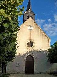 The church in Senneçay | |
.svg.png) Coat of arms | |
Location of Senneçay 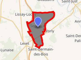
| |
 Senneçay  Senneçay | |
| Coordinates: 46°57′07″N 2°26′16″E | |
| Country | France |
| Region | Centre-Val de Loire |
| Department | Cher |
| Arrondissement | Bourges |
| Canton | Trouy |
| Intercommunality | CC Le Dunois |
| Government | |
| • Mayor (2008–2014) | Gérard Rouzeau |
| Area 1 | 14.47 km2 (5.59 sq mi) |
| Population (2017-01-01)[1] | 472 |
| • Density | 33/km2 (84/sq mi) |
| Time zone | UTC+01:00 (CET) |
| • Summer (DST) | UTC+02:00 (CEST) |
| INSEE/Postal code | 18248 /18340 |
| Elevation | 154–181 m (505–594 ft) (avg. 172 m or 564 ft) |
| 1 French Land Register data, which excludes lakes, ponds, glaciers > 1 km2 (0.386 sq mi or 247 acres) and river estuaries. | |
Geography
Senneçay is a farming village situated about 10 miles (16 km) south of Bourges, at the junction of the D46 and the D34 roads. The A71 autoroute forms the commune’s western border.
Population
| Year | Pop. | ±% |
|---|---|---|
| 1962 | 305 | — |
| 1968 | 328 | +7.5% |
| 1975 | 288 | −12.2% |
| 1982 | 258 | −10.4% |
| 1990 | 347 | +34.5% |
| 1999 | 345 | −0.6% |
| 2008 | 435 | +26.1% |
Sights
- The church of St. Pierre, dating from the thirteenth century.
gollark: Their graphics drivers also work really well on Linux too. It's weird.
gollark: They have lots of those redundantly.
gollark: I imagine it would still *mostly* work for a while, and people could migrate off.
gollark: It's not as if much of the internet *physically* runs through one wire or something, that would be ridiculous, it's a big internet.
gollark: I mean, the closest you would get is... maybe wiping out some important root signing key?
See also
External links
| Wikimedia Commons has media related to Senneçay. |
- Senneçay on the Quid website (in French)
This article is issued from Wikipedia. The text is licensed under Creative Commons - Attribution - Sharealike. Additional terms may apply for the media files.