Bannegon
Bannegon is a commune in the Cher department in the Centre-Val de Loire region of France.
Bannegon | |
|---|---|
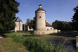 Chateau | |
Location of Bannegon 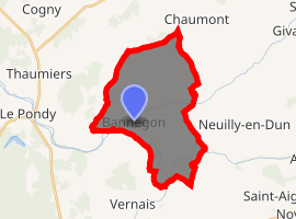
| |
 Bannegon  Bannegon | |
| Coordinates: 46°48′07″N 2°42′51″E | |
| Country | France |
| Region | Centre-Val de Loire |
| Department | Cher |
| Arrondissement | Saint-Amand-Montrond |
| Canton | Dun-sur-Auron |
| Intercommunality | CC Le Dunois |
| Government | |
| • Mayor (2008–2014) | Guy James |
| Area 1 | 21.08 km2 (8.14 sq mi) |
| Population (2017-01-01)[1] | 274 |
| • Density | 13/km2 (34/sq mi) |
| Time zone | UTC+01:00 (CET) |
| • Summer (DST) | UTC+02:00 (CEST) |
| INSEE/Postal code | 18021 /18210 |
| Elevation | 173–256 m (568–840 ft) (avg. 200 m or 660 ft) |
| 1 French Land Register data, which excludes lakes, ponds, glaciers > 1 km2 (0.386 sq mi or 247 acres) and river estuaries. | |
Geography
A farming area comprising the village and several hamlets situated by the banks of both the river Auron and the disused Canal de Berry some 25 miles (40 km) southeast of Bourges at the junction of the D110 with the D41 and D74 roads.
Population
| Year | Pop. | ±% |
|---|---|---|
| 1962 | 368 | — |
| 1968 | 383 | +4.1% |
| 1975 | 351 | −8.4% |
| 1982 | 297 | −15.4% |
| 1990 | 260 | −12.5% |
| 1999 | 254 | −2.3% |
| 2008 | 270 | +6.3% |
Places of interest
- The church of St.Sulpice, dating from the thirteenth century.
- The twelfth-century castle of Bannegon.
gollark: Yes, it's 2020 so use IPoAC.
gollark: In-home IPoAC will become the most common way to network soon, mark my words.
gollark: Betterestestetsttest idea: IP over Avian Carriers.
gollark: Betterestest idea: just disconnect the power lines from the actual electrical supply and use them for networking only.
gollark: Sure!
See also
References
- "Populations légales 2017". INSEE. Retrieved 6 January 2020.
| Wikimedia Commons has media related to Bannegon. |
| Authority control |
|
|---|
This article is issued from Wikipedia. The text is licensed under Creative Commons - Attribution - Sharealike. Additional terms may apply for the media files.