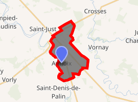
Annoix
Annoix is a commune in the Cher department in the Centre-Val de Loire region of France.
Annoix | |
|---|---|
.svg.png) Coat of arms | |
Location of Annoix 
| |
 Annoix  Annoix | |
| Coordinates: 46°57′39″N 2°32′06″E | |
| Country | France |
| Region | Centre-Val de Loire |
| Department | Cher |
| Arrondissement | Bourges |
| Canton | Trouy |
| Intercommunality | Bourges Plus |
| Government | |
| • Mayor (2014-2020) | Alain Mazé |
| Area 1 | 11.79 km2 (4.55 sq mi) |
| Population (2017-01-01)[1] | 233 |
| • Density | 20/km2 (51/sq mi) |
| Time zone | UTC+01:00 (CET) |
| • Summer (DST) | UTC+02:00 (CEST) |
| INSEE/Postal code | 18006 /18340 |
| Elevation | 142–179 m (466–587 ft) (avg. 175 m or 574 ft) |
| 1 French Land Register data, which excludes lakes, ponds, glaciers > 1 km2 (0.386 sq mi or 247 acres) and river estuaries. | |
Geography
A farming area comprising the village and a hamlet situated by the banks of the Auron River some 12 miles (19 km) southeast of Bourges, at the junction of the D119, D953 and the D2076 roads.
Population
| Year | Pop. | ±% |
|---|---|---|
| 2004 | 238 | — |
| 2006 | 231 | −2.9% |
| 2007 | 229 | −0.9% |
| 2008 | 228 | −0.4% |
| 2009 | 227 | −0.4% |
| 2010 | 231 | +1.8% |
| 2011 | 230 | −0.4% |
| 2012 | 232 | +0.9% |
| 2013 | 235 | +1.3% |
| 2014 | 237 | +0.9% |
| 2015 | 234 | −1.3% |
| 2016 | 231 | −1.3% |
Sights
- The church of St.Pierre, dating from the twelfth century and restored between 1837 and 1840.
- The remains of a Roman aqueduct.
- An old watermill.
- The Château Gaillard.
gollark: <@259973943060856833> If you rented a VM for Krist that would probably - without special configuration - only allow CPU mining. Which is too slow.
gollark: To be fair, Knights Whatever were Xeon Phi and now cancelled, I think. But still.
gollark: Intel: making perfect sense all the time™™™.
gollark: If you think the SHA-whatever support is bad, look at the weird Venn diagrams for AVX-512!
gollark: Yes, Krist has a lot of inequality since mining rewards were 50 times higher a few years back.
See also
References
- "Populations légales 2017". INSEE. Retrieved 6 January 2020.
| Wikimedia Commons has media related to Annoix. |
This article is issued from Wikipedia. The text is licensed under Creative Commons - Attribution - Sharealike. Additional terms may apply for the media files.