Azy, Cher
Azy is a commune in the Cher department in the Centre-Val de Loire region of France.
Azy | |
|---|---|
Location of Azy 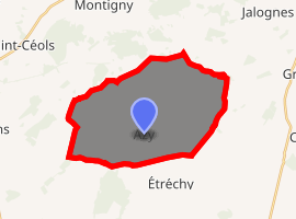
| |
 Azy  Azy | |
| Coordinates: 47°11′02″N 2°42′30″E | |
| Country | France |
| Region | Centre-Val de Loire |
| Department | Cher |
| Arrondissement | Bourges |
| Canton | Saint-Germain-du-Puy |
| Intercommunality | Terres du Haut Berry |
| Government | |
| • Mayor (2014-2020) | Caroline Chauveau |
| Area 1 | 27.62 km2 (10.66 sq mi) |
| Population (2017-01-01)[1] | 445 |
| • Density | 16/km2 (42/sq mi) |
| Time zone | UTC+01:00 (CET) |
| • Summer (DST) | UTC+02:00 (CEST) |
| INSEE/Postal code | 18019 /18220 |
| Elevation | 179–241 m (587–791 ft) (avg. 205 m or 673 ft) |
| 1 French Land Register data, which excludes lakes, ponds, glaciers > 1 km2 (0.386 sq mi or 247 acres) and river estuaries. | |
Geography
A farming area comprising the village and several hamlets situated by the banks of the river Fromion, some 13 miles (21 km) northeast of Bourges at the junction of the D25 with the D93 and the D52 roads.
Population
| Year | Pop. | ±% |
|---|---|---|
| 2006 | 477 | — |
| 2007 | 474 | −0.6% |
| 2008 | 473 | −0.2% |
| 2009 | 479 | +1.3% |
| 2010 | 484 | +1.0% |
| 2011 | 489 | +1.0% |
| 2012 | 489 | +0.0% |
| 2013 | 487 | −0.4% |
| 2014 | 471 | −3.3% |
| 2015 | 458 | −2.8% |
| 2016 | 445 | −2.8% |
Places of interest
- The church of St.Sulpice, dating from the thirteenth century.
gollark: They're very strongly correlated.
gollark: Wrong. GTech™ is self-causing.
gollark: Of course, I doubt SUSCorp™ has sufficient simulation ability for this to be a problem.
gollark: Maybe not when calculating rough approximations to apionic systems, but if you try and extrapolate forward by more than 22🐝 or so you'll get cascading errors.
gollark: It entirely ignores the effects of the third derivatives of the apionic conjugate transpose matrices.
See also
External links
| Wikimedia Commons has media related to Azy. |
- Azy on the Quid website (in French)
| Authority control |
|
|---|
This article is issued from Wikipedia. The text is licensed under Creative Commons - Attribution - Sharealike. Additional terms may apply for the media files.