La Celle, Cher
La Celle is a commune in the Cher department in the Centre-Val de Loire region of France.
La Celle | |
|---|---|
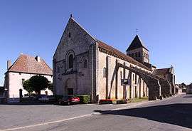 The church of Saint-Blaise | |
.svg.png) Coat of arms | |
Location of La Celle 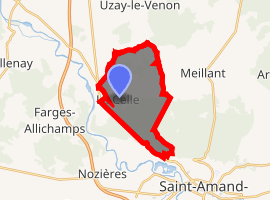
| |
 La Celle  La Celle | |
| Coordinates: 46°46′11″N 2°26′50″E | |
| Country | France |
| Region | Centre-Val de Loire |
| Department | Cher |
| Arrondissement | Saint-Amand-Montrond |
| Canton | Saint-Amand-Montrond |
| Intercommunality | Cœur de France |
| Government | |
| • Mayor (2008–2014) | Christian Touraud |
| Area 1 | 12.8 km2 (4.9 sq mi) |
| Population (2017-01-01)[1] | 348 |
| • Density | 27/km2 (70/sq mi) |
| Time zone | UTC+01:00 (CET) |
| • Summer (DST) | UTC+02:00 (CEST) |
| INSEE/Postal code | 18042 /18200 |
| Elevation | 149–247 m (489–810 ft) (avg. 125 m or 410 ft) |
| 1 French Land Register data, which excludes lakes, ponds, glaciers > 1 km2 (0.386 sq mi or 247 acres) and river estuaries. | |
Geography
An area of forestry and farming comprising the village and two hamlets situated in the valley of the Cher River, some 23 miles (37 km) south of Bourges near the junction of the D2144 and the D92 roads.
Population
| Year | Pop. | ±% |
|---|---|---|
| 1962 | 317 | — |
| 1968 | 342 | +7.9% |
| 1975 | 264 | −22.8% |
| 1982 | 264 | +0.0% |
| 1990 | 291 | +10.2% |
| 1999 | 328 | +12.7% |
| 2008 | 361 | +10.1% |
Sights
- The church of St. Blaise, dating from the twelfth century.
- The fifteenth century chapel of St. Sylvain.
gollark: This looks like a scene from a bad movie with robots in it, where code scrolls across their vision for no reason.
gollark: You could use an outofgame relay and Holy Websockets.
gollark: Maybe it can't send fast enough so some get dropped.
gollark: BĀNANA
gollark: Do you like TIS-100?
See also
References
- "Populations légales 2017". INSEE. Retrieved 6 January 2020.
| Wikimedia Commons has media related to La Celle (Cher). |
| Authority control |
|
|---|
This article is issued from Wikipedia. The text is licensed under Creative Commons - Attribution - Sharealike. Additional terms may apply for the media files.