Précy
Précy is a commune in the Cher department in the Centre-Val de Loire region of France.
Précy | |
|---|---|
.JPG) The town hall in Précy | |
Location of Précy 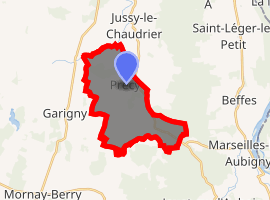
| |
 Précy  Précy | |
| Coordinates: 47°06′01″N 2°55′47″E | |
| Country | France |
| Region | Centre-Val de Loire |
| Department | Cher |
| Arrondissement | Bourges |
| Canton | Avord |
| Government | |
| • Mayor (2008–2014) | Joël Vignel |
| Area 1 | 14.45 km2 (5.58 sq mi) |
| Population (2017-01-01)[1] | 345 |
| • Density | 24/km2 (62/sq mi) |
| Time zone | UTC+01:00 (CET) |
| • Summer (DST) | UTC+02:00 (CEST) |
| INSEE/Postal code | 18184 /18140 |
| Elevation | 168–197 m (551–646 ft) (avg. 150 m or 490 ft) |
| 1 French Land Register data, which excludes lakes, ponds, glaciers > 1 km2 (0.386 sq mi or 247 acres) and river estuaries. | |
Geography
An area of forestry and farming comprising the village and a couple of hamlets situated some 23 miles (37 km) east of Bourges, at the junction of the D51, D920, D48 and the D81 roads. The river Vauvise forms all of the commune's northern boundary.
Population
| Year | Pop. | ±% |
|---|---|---|
| 1962 | 320 | — |
| 1968 | 372 | +16.3% |
| 1975 | 285 | −23.4% |
| 1982 | 262 | −8.1% |
| 1990 | 301 | +14.9% |
| 1999 | 312 | +3.7% |
| 2008 | 336 | +7.7% |
Sights
- The church of St. Louis, dating from the sixteenth century.
- A feudal motte at the place known as Château de Faye.
- A seventeenth-century chateau.
- A converted watermill.
gollark: It has 1GB of total RAM which I can split between the VC4 and ARM cores as desired.
gollark: Although there is composite video output and a MIPI-DSI port.
gollark: I believe it can do 4K, but only on one monitor.
gollark: Recent models have an interface for optional external uhs.
gollark: It is not currently believed to be sapient.
See also
References
- "Populations légales 2017". INSEE. Retrieved 6 January 2020.
| Wikimedia Commons has media related to Précy. |
| Authority control |
|
|---|
This article is issued from Wikipedia. The text is licensed under Creative Commons - Attribution - Sharealike. Additional terms may apply for the media files.