Ménétréol-sous-Sancerre
Ménétréol-sous-Sancerre is a commune in the Cher department in the Centre-Val de Loire region of France.
Ménétréol-sous-Sancerre | |
|---|---|
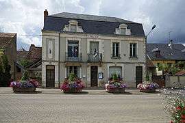 The town hall in Ménétréol-sous-Sancerre | |
Location of Ménétréol-sous-Sancerre 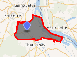
| |
 Ménétréol-sous-Sancerre  Ménétréol-sous-Sancerre | |
| Coordinates: 47°19′07″N 2°51′24″E | |
| Country | France |
| Region | Centre-Val de Loire |
| Department | Cher |
| Arrondissement | Bourges |
| Canton | Sancerre |
| Intercommunality | CC Pays Fort Sancerrois Val de Loire |
| Government | |
| • Mayor (2001–2008) | Roger Laurent |
| Area 1 | 5.67 km2 (2.19 sq mi) |
| Population (2017-01-01)[1] | 315 |
| • Density | 56/km2 (140/sq mi) |
| Time zone | UTC+01:00 (CET) |
| • Summer (DST) | UTC+02:00 (CEST) |
| INSEE/Postal code | 18146 /18300 |
| Elevation | 142–252 m (466–827 ft) (avg. 185 m or 607 ft) |
| 1 French Land Register data, which excludes lakes, ponds, glaciers > 1 km2 (0.386 sq mi or 247 acres) and river estuaries. | |
Geography
A winegrowing and farming village situated by the banks of the rivers Vauvise and Loire and the Loire lateral canal, some 26 miles (42 km) northeast of Bourges, at the junction of the D9 with the D920 and the D307 roads. The Sauvignon blanc grapes grown here are used for Sancerre AOC wines.
Population
| Year | Pop. | ±% |
|---|---|---|
| 1962 | 374 | — |
| 1968 | 390 | +4.3% |
| 1975 | 436 | +11.8% |
| 1982 | 389 | −10.8% |
| 1990 | 353 | −9.3% |
| 1999 | 354 | +0.3% |
| 2008 | 378 | +6.8% |
Sights
- The church of St. Hilaire, dating from the seventeenth century.
- The restored watermill.
- The twelfth-century chateau des Aubelles and its chapel.
- The small port on the canal.
- The nineteenth-century railway viaduct.
gollark: Well, the "how you did it" is... also often your work.
gollark: ++delete discord (cooldown)
gollark: C bad because it has no generics.
gollark: æææææææææĸĸæææææææææææłłłłłłłłææææææaa
gollark: JUST ALTGR
See also
References
- "Populations légales 2017". INSEE. Retrieved 6 January 2020.
External links
| Wikimedia Commons has media related to Ménétréol-sous-Sancerre. |
- Maps and photographs of the commune (in French)
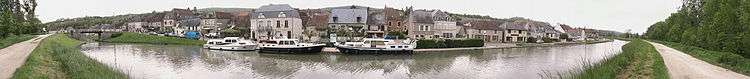
Panoramic view of Menetreol
This article is issued from Wikipedia. The text is licensed under Creative Commons - Attribution - Sharealike. Additional terms may apply for the media files.