Chambon, Cher
Chambon is a commune in the Cher department in the Centre-Val de Loire region of France.
Chambon | |
|---|---|
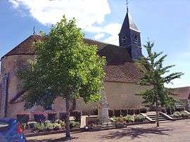 The church of Saint-Pierre, in Chambon | |
Location of Chambon 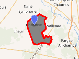
| |
 Chambon  Chambon | |
| Coordinates: 46°47′16″N 2°19′32″E | |
| Country | France |
| Region | Centre-Val de Loire |
| Department | Cher |
| Arrondissement | Saint-Amand-Montrond |
| Canton | Trouy |
| Intercommunality | CC Arnon Boischaut Cher |
| Government | |
| • Mayor (2008–2014) | Gérard Lucas |
| Area 1 | 13.91 km2 (5.37 sq mi) |
| Population (2017-01-01)[1] | 173 |
| • Density | 12/km2 (32/sq mi) |
| Time zone | UTC+01:00 (CET) |
| • Summer (DST) | UTC+02:00 (CEST) |
| INSEE/Postal code | 18046 /18190 |
| Elevation | 147–187 m (482–614 ft) (avg. 170 m or 560 ft) |
| 1 French Land Register data, which excludes lakes, ponds, glaciers > 1 km2 (0.386 sq mi or 247 acres) and river estuaries. | |
Geography
A small farming village situated by the banks of the river Trian some 21 miles (34 km) south of Bourges at the junction of the D73 with the D192 road.
Population
| Year | Pop. | ±% |
|---|---|---|
| 1962 | 215 | — |
| 1968 | 231 | +7.4% |
| 1975 | 195 | −15.6% |
| 1982 | 143 | −26.7% |
| 1990 | 122 | −14.7% |
| 1999 | 134 | +9.8% |
| 2008 | 148 | +10.4% |
Sights
- The church of St. Pierre, dating from the twelfth century
gollark: Idea: BF, but with COMPRESSION, so it wins all code golf.
gollark: They are COOL™ and TRENDY™ and would allow some efficiency optimizations such as being able to send data to clients on changes only for higher efficiency.
gollark: Maybe I should switch my thingy to websockets.
gollark: Sadly, that may be the cæse!
gollark: Yes, for unrelated events.
See also
References
- "Populations légales 2017". INSEE. Retrieved 6 January 2020.
| Wikimedia Commons has media related to Chambon (Cher). |
| Authority control |
|
|---|
This article is issued from Wikipedia. The text is licensed under Creative Commons - Attribution - Sharealike. Additional terms may apply for the media files.