Tendron
Tendron is a commune in the Cher department in the Centre-Val de Loire region of France.
Tendron | |
|---|---|
Location of Tendron 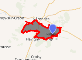
| |
 Tendron  Tendron | |
| Coordinates: 46°59′00″N 2°48′38″E | |
| Country | France |
| Region | Centre-Val de Loire |
| Department | Cher |
| Arrondissement | Saint-Amand-Montrond |
| Canton | La Guerche-sur-l'Aubois |
| Intercommunality | CC Pays de Nérondes |
| Government | |
| • Mayor (2008–2014) | Jean-Louis de Gourcuff |
| Area 1 | 10.44 km2 (4.03 sq mi) |
| Population (2017-01-01)[1] | 93 |
| • Density | 8.9/km2 (23/sq mi) |
| Time zone | UTC+01:00 (CET) |
| • Summer (DST) | UTC+02:00 (CEST) |
| INSEE/Postal code | 18260 /18350 |
| Elevation | 176–263 m (577–863 ft) (avg. 250 m or 820 ft) |
| 1 French Land Register data, which excludes lakes, ponds, glaciers > 1 km2 (0.386 sq mi or 247 acres) and river estuaries. | |
Geography
A farming village situated about 23 miles (37 km) southeast of Bourges near the junction of the D43 with the D6 road. The river Airain flows southwest through the northwestern part of the commune.
Population
| Year | Pop. | ±% |
|---|---|---|
| 1962 | 120 | — |
| 1968 | 132 | +10.0% |
| 1975 | 118 | −10.6% |
| 1982 | 99 | −16.1% |
| 1990 | 122 | +23.2% |
| 1999 | 110 | −9.8% |
| 2008 | 121 | +10.0% |
Places of interest
- The eighteenth-century chateau of Fontenay.
gollark: Oh, that's my GPT-based ubq emulation.
gollark: ABR colorizes it, see.
gollark: it did, great.
gollark: ++tel init_webhook
gollark: Right. Yes. That.
See also
External links
| Wikimedia Commons has media related to Tendron. |
- Tendron on the Annuaire Mairie website (in French)
| Authority control |
|
|---|
This article is issued from Wikipedia. The text is licensed under Creative Commons - Attribution - Sharealike. Additional terms may apply for the media files.