Saint-Outrille
Saint-Outrille is a commune in the Cher department in the Centre-Val de Loire region of France. It is named after the 7th century Saint Austregisilus.
Saint-Outrille | |
|---|---|
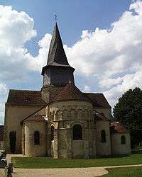 The collegiate church of Saint-Austrégésile, in Saint-Outrille | |
Location of Saint-Outrille 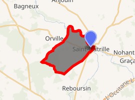
| |
 Saint-Outrille  Saint-Outrille | |
| Coordinates: 47°08′41″N 1°50′28″E | |
| Country | France |
| Region | Centre-Val de Loire |
| Department | Cher |
| Arrondissement | Vierzon |
| Canton | Vierzon-2 |
| Intercommunality | CC Vierzon-Sologne-Berry et Villages de la Forêt |
| Government | |
| • Mayor (2008–2014) | Laurent Georges |
| Area 1 | 12.48 km2 (4.82 sq mi) |
| Population (2017-01-01)[1] | 220 |
| • Density | 18/km2 (46/sq mi) |
| Time zone | UTC+01:00 (CET) |
| • Summer (DST) | UTC+02:00 (CEST) |
| INSEE/Postal code | 18228 /18310 |
| Elevation | 97–151 m (318–495 ft) (avg. 106 m or 348 ft) |
| 1 French Land Register data, which excludes lakes, ponds, glaciers > 1 km2 (0.386 sq mi or 247 acres) and river estuaries. | |
Geography
An area of farmland, forests and a village suburb on the left bank of the Fouzon river, which forms the boundary with the much larger village of Graçay, situated about 12 miles (19 km) southwest of Vierzon near the junction of the D68 with the D83 and D922 roads. The commune borders the department of Indre.
Population
| Year | Pop. | ±% |
|---|---|---|
| 1962 | 273 | — |
| 1968 | 284 | +4.0% |
| 1975 | 294 | +3.5% |
| 1982 | 288 | −2.0% |
| 1990 | 259 | −10.1% |
| 1999 | 203 | −21.6% |
| 2008 | 216 | +6.4% |
Sights
- The church of St. Austrégesile, dating from the twelfth century.
gollark: you cannot escapeTHE TROUT
gollark: It's compiled *to bytecode*.
gollark: Like the osmarks.tk firefox crasher (I think that got patched).
gollark: Yes, that is true for all pages.
gollark: γρεεκ ρεαδερς ἀρε θε κοολεστ.
See also
References
- "Populations légales 2017". INSEE. Retrieved 6 January 2020.
| Wikimedia Commons has media related to Saint-Outrille. |
| Authority control |
|
|---|
This article is issued from Wikipedia. The text is licensed under Creative Commons - Attribution - Sharealike. Additional terms may apply for the media files.