Brinon-sur-Sauldre
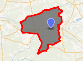
Brinon-sur-Sauldre is a commune in the Cher department in the Centre-Val de Loire region of France.
Brinon-sur-Sauldre | |
|---|---|
Location of Brinon-sur-Sauldre 
| |
 Brinon-sur-Sauldre  Brinon-sur-Sauldre | |
| Coordinates: 47°33′56″N 2°15′21″E | |
| Country | France |
| Region | Centre-Val de Loire |
| Department | Cher |
| Arrondissement | Vierzon |
| Canton | Aubigny-sur-Nère |
| Intercommunality | Sauldre et Sologne |
| Government | |
| • Mayor (2008–2014) | Dominique Girard |
| Area 1 | 116.3 km2 (44.9 sq mi) |
| Population (2017-01-01)[1] | 982 |
| • Density | 8.4/km2 (22/sq mi) |
| Time zone | UTC+01:00 (CET) |
| • Summer (DST) | UTC+02:00 (CEST) |
| INSEE/Postal code | 18037 /18410 |
| Elevation | 118–162 m (387–531 ft) (avg. 138 m or 453 ft) |
| 1 French Land Register data, which excludes lakes, ponds, glaciers > 1 km2 (0.386 sq mi or 247 acres) and river estuaries. | |
Geography
A village of lakes, forestry and farming situated in the valley of the river Sauldre, some 31 miles (50 km) north of Bourges at the junction of the D234, D77 and the D923 roads. The commune has the Beuvron river forming its northern border with the department of Loir-et-Cher.
Population
| Year | Pop. | ±% |
|---|---|---|
| 1962 | 1,224 | — |
| 1968 | 1,332 | +8.8% |
| 1975 | 1,293 | −2.9% |
| 1982 | 1,249 | −3.4% |
| 1990 | 1,107 | −11.4% |
| 1999 | 1,089 | −1.6% |
| 2008 | 1,044 | −4.1% |
Sights
- The church of St. Barthélemy, dating from the eleventh century.
- Traces of a thirteenth-century castle at Launay.
gollark: ```cvoid* malloc(size_t n) { printf("Kernel panic. Shutting down."); exit(-3)}```
gollark: Then we need it.
gollark: Not in performance though.
gollark: Well, it beats osmarkslibc malloc.
gollark: > a functional (!) implementation of malloc/free using linked lists can easily be done in under 100 linesThat is one case where linked lists may make some sense. Otherwise, not really.
See also
References
- "Populations légales 2017". INSEE. Retrieved 6 January 2020.
External links
| Wikimedia Commons has media related to Brinon-sur-Sauldre. |
- Official website of the commune (in French)
This article is issued from Wikipedia. The text is licensed under Creative Commons - Attribution - Sharealike. Additional terms may apply for the media files.