Sainte-Montaine
Sainte-Montaine is a commune in the Cher department in the Centre-Val de Loire region of France.
Sainte-Montaine | |
|---|---|
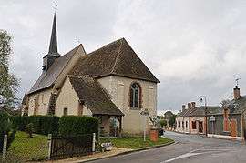 The church in Sainte-Montaine | |
Location of Sainte-Montaine 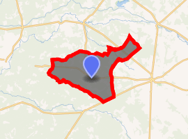
| |
 Sainte-Montaine  Sainte-Montaine | |
| Coordinates: 47°29′28″N 2°19′15″E | |
| Country | France |
| Region | Centre-Val de Loire |
| Department | Cher |
| Arrondissement | Vierzon |
| Canton | Aubigny-sur-Nère |
| Intercommunality | Sauldre et Sologne |
| Government | |
| • Mayor (2008–2014) | Olivier Debarre |
| Area 1 | 53.79 km2 (20.77 sq mi) |
| Population (2017-01-01)[1] | 181 |
| • Density | 3.4/km2 (8.7/sq mi) |
| Time zone | UTC+01:00 (CET) |
| • Summer (DST) | UTC+02:00 (CEST) |
| INSEE/Postal code | 18227 /18700 |
| Elevation | 133–183 m (436–600 ft) (avg. 167 m or 548 ft) |
| 1 French Land Register data, which excludes lakes, ponds, glaciers > 1 km2 (0.386 sq mi or 247 acres) and river estuaries. | |
Geography
An area of streams, lakes, forestry and farming comprising a small village and two hamlets situated some 28 miles (45 km) north of Bourges at the junction of the D79, D180 and D13 roads. The small river Boute-Vive rises in the commune.
Population
| Year | Pop. | ±% |
|---|---|---|
| 1962 | 216 | — |
| 1968 | 253 | +17.1% |
| 1975 | 226 | −10.7% |
| 1982 | 233 | +3.1% |
| 1990 | 206 | −11.6% |
| 1999 | 170 | −17.5% |
| 2008 | 212 | +24.7% |
Personalities
- Marguerite Audoux (1863- 1937), French novelist, lived here in her youth.
Sights
- The church, dating from the fifteenth century.
- The feudal motte.
- The chapel of Belle Fontaine.
gollark: No idea why my USB works and the actual thing doesn't.
gollark: I'm tempted to just reinstall arch entirely, but this would likely bee all things further.
gollark: I assume it's just knowledge of the commodities.
gollark: Not individually, or you would just die when you broke your leg or something.
gollark: As far as I know you would have gone around in a small tightly-knit group doing your gathery things.
See also
References
- "Populations légales 2017". INSEE. Retrieved 6 January 2020.
| Wikimedia Commons has media related to Sainte-Montaine. |
| Authority control |
|
|---|
This article is issued from Wikipedia. The text is licensed under Creative Commons - Attribution - Sharealike. Additional terms may apply for the media files.