Couy
Couy is a commune in the Cher department in the Centre-Val de Loire region of France.
Couy | |
|---|---|
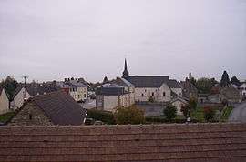 A general view of Couy | |
.svg.png) Coat of arms | |
Location of Couy 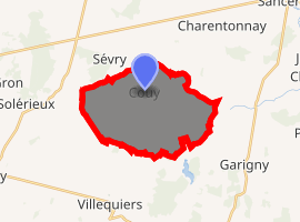
| |
 Couy  Couy | |
| Coordinates: 47°07′05″N 2°49′35″E | |
| Country | France |
| Region | Centre-Val de Loire |
| Department | Cher |
| Arrondissement | Bourges |
| Canton | Avord |
| Government | |
| • Mayor (2020–2026) | Philippe Policard |
| Area 1 | 18.36 km2 (7.09 sq mi) |
| Population (2017-01-01)[1] | 355 |
| • Density | 19/km2 (50/sq mi) |
| Time zone | UTC+01:00 (CET) |
| • Summer (DST) | UTC+02:00 (CEST) |
| INSEE/Postal code | 18077 /18140 |
| Elevation | 171–219 m (561–719 ft) |
| 1 French Land Register data, which excludes lakes, ponds, glaciers > 1 km2 (0.386 sq mi or 247 acres) and river estuaries. | |
Geography
A farming area comprising the village and one hamlet situated some 19 miles (31 km) east of Bourges at the junction of the D53 and the D72 roads. The river Vauvise flows northeastward through the eastern part of the commune.
Population
| Year | Pop. | ±% |
|---|---|---|
| 1962 | 383 | — |
| 1968 | 417 | +8.9% |
| 1975 | 371 | −11.0% |
| 1982 | 305 | −17.8% |
| 1990 | 308 | +1.0% |
| 1999 | 334 | +8.4% |
| 2008 | 374 | +12.0% |
Sights
- The church of St. Martin, dating from the thirteenth century.
- The eighteenth-century manorhouse at Creu.
gollark: There are two of them, see.
gollark: No.
gollark: It's very exciting.
gollark: Like I said, we're working on transubstantiation-based iron extraction.
gollark: "Oh yes, I will just go OUTSIDE the universe" - statements made by GTech™ exploration probe #15996-υ/4.
See also
References
- "Populations légales 2017". INSEE. Retrieved 6 January 2020.
| Wikimedia Commons has media related to Couy. |
| Authority control |
|
|---|
This article is issued from Wikipedia. The text is licensed under Creative Commons - Attribution - Sharealike. Additional terms may apply for the media files.