Thérouldeville
Thérouldeville is a commune in the Seine-Maritime department in the Normandy region in northern France.
Thérouldeville | |
|---|---|
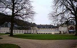 The abbey in Valmont | |
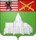 Coat of arms | |
Location of Thérouldeville 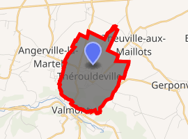
| |
 Thérouldeville  Thérouldeville | |
| Coordinates: 49°45′34″N 0°31′27″E | |
| Country | France |
| Region | Normandy |
| Department | Seine-Maritime |
| Arrondissement | Le Havre |
| Canton | Fécamp |
| Intercommunality | CA Fécamp Caux Littoral |
| Government | |
| • Mayor | Alain Bazille |
| Area 1 | 4.58 km2 (1.77 sq mi) |
| Population (2017-01-01)[1] | 664 |
| • Density | 140/km2 (380/sq mi) |
| Time zone | UTC+01:00 (CET) |
| • Summer (DST) | UTC+02:00 (CEST) |
| INSEE/Postal code | 76685 /76540 |
| Elevation | 54–131 m (177–430 ft) (avg. 120 m or 390 ft) |
| 1 French Land Register data, which excludes lakes, ponds, glaciers > 1 km2 (0.386 sq mi or 247 acres) and river estuaries. | |
Geography
A farming village in the woodland valley of the Valmont River in the Pays de Caux, situated some 29 miles (47 km) northeast of Le Havre, at the junction of the D33, D69 and D17 roads.
Heraldry
Arms of Thérouldeville |
The arms of Thérouldeville are blazoned : Vert, the local church in profile, door to dexter argent, a chief per pale 1: barry argent and gules, a lion sable crowned Or; and 2: gules, 2 swords in saltire Or. |
Population
| 1962 | 1968 | 1975 | 1982 | 1990 | 1999 | 2006 |
|---|---|---|---|---|---|---|
| 334 | 360 | 292 | 340 | 423 | 457 | 517 |
| Starting in 1962: Population without duplicates | ||||||
Places of interest
- The church of St. Pierre and St. Paul, dating from the sixteenth century.
- The remains of Valmont Abbey.
External links
| Wikimedia Commons has media related to Thérouldeville. |
- Thérouldeville on the Quid website (in French)
| Authority control |
|
|---|
This article is issued from Wikipedia. The text is licensed under Creative Commons - Attribution - Sharealike. Additional terms may apply for the media files.