Servaville-Salmonville
Servaville-Salmonville is a commune in the Seine-Maritime department in the Normandy region in northern France.
Servaville-Salmonville | |
|---|---|
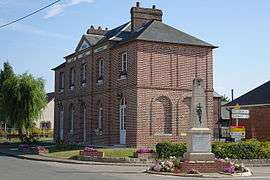 The town hall in Servaville-Salmonville | |
Location of Servaville-Salmonville 
| |
 Servaville-Salmonville  Servaville-Salmonville | |
| Coordinates: 49°28′37″N 1°16′20″E | |
| Country | France |
| Region | Normandy |
| Department | Seine-Maritime |
| Arrondissement | Rouen |
| Canton | Le Mesnil-Esnard |
| Intercommunality | Plateau de Martainville |
| Government | |
| • Mayor | Joannès Dugelay |
| Area 1 | 7.85 km2 (3.03 sq mi) |
| Population (2017-01-01)[1] | 1,133 |
| • Density | 140/km2 (370/sq mi) |
| Time zone | UTC+01:00 (CET) |
| • Summer (DST) | UTC+02:00 (CEST) |
| INSEE/Postal code | 76673 /76116 |
| Elevation | 148–172 m (486–564 ft) (avg. 165 m or 541 ft) |
| 1 French Land Register data, which excludes lakes, ponds, glaciers > 1 km2 (0.386 sq mi or 247 acres) and river estuaries. | |
Geography
A farming village situated in Normandy, some 8 miles (13 km) east of Rouen at the junction of the D7, D62 and the D453 roads. The N31 road forms the commune's southern border.
Population
| 1962 | 1968 | 1975 | 1982 | 1990 | 1999 | 2006 |
|---|---|---|---|---|---|---|
| 295 | 308 | 460 | 523 | 647 | 778 | 1029 |
| Starting in 1962: Population without duplicates | ||||||
Places of interest
- The church of St. Clement, dating from the thirteenth century.
- A seventeenth-century stone cross.
- The eighteenth-century manorhouse of Hémaudière.
References
- "Populations légales 2017". INSEE. Retrieved 6 January 2020.
| Wikimedia Commons has media related to Servaville-Salmonville. |
| Authority control |
|
|---|
This article is issued from Wikipedia. The text is licensed under Creative Commons - Attribution - Sharealike. Additional terms may apply for the media files.