Longueville-sur-Scie
Longueville-sur-Scie is a commune in the Seine-Maritime department in the Normandy region in northern France.
Longueville-sur-Scie | |
|---|---|
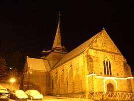 The church in Longueville-sur-Scie | |
 Coat of arms | |
Location of Longueville-sur-Scie 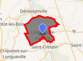
| |
 Longueville-sur-Scie  Longueville-sur-Scie | |
| Coordinates: 49°47′34″N 1°06′37″E | |
| Country | France |
| Region | Normandy |
| Department | Seine-Maritime |
| Arrondissement | Dieppe |
| Canton | Luneray |
| Intercommunality | CC Terroir de Caux |
| Government | |
| • Mayor (2001–2008) | Serge Boulanger |
| Area 1 | 3.96 km2 (1.53 sq mi) |
| Population (2017-01-01)[1] | 980 |
| • Density | 250/km2 (640/sq mi) |
| Time zone | UTC+01:00 (CET) |
| • Summer (DST) | UTC+02:00 (CEST) |
| INSEE/Postal code | 76397 /76590 |
| Elevation | 52–139 m (171–456 ft) (avg. 95 m or 312 ft) |
| 1 French Land Register data, which excludes lakes, ponds, glaciers > 1 km2 (0.386 sq mi or 247 acres) and river estuaries. | |
Geography
A farming village situated by the banks of the river Scie in the Pays de Caux, some 9 miles (14 km) south of Dieppe at the junction of the D77, the D149 and the D3 roads. The commune is served by the TER railway between Dieppe and Rouen.
Coat of arms
Arms of Longueville-sur-Scie |
The arms of Longueville-sur-Scie are blazoned : Gules, a triple-towered castle argent masoned sable with a portcullis Or, in sinister chief a falcon volant sable. |
Population
| 1962 | 1968 | 1975 | 1982 | 1990 | 1999 | 2006 |
|---|---|---|---|---|---|---|
| 725 | 801 | 764 | 844 | 820 | 936 | 949 |
| Starting in 1962: Population without duplicates | ||||||
Places of interest
- The church of St.Pierre, dating from the eleventh century.
- Ruins of an 11th-century castle, built by Walter Giffard, Lord of Longueville.
Miscellany
The village was formerly known as Longueville-le-Giffard, one of its sons was Osbern Giffard, who gave his name to Stoke Gifford, South Gloucestershire, England.
References
- "Populations légales 2017". INSEE. Retrieved 6 January 2020.
| Wikimedia Commons has media related to Longueville-sur-Scie. |
| Authority control |
|
|---|
This article is issued from Wikipedia. The text is licensed under Creative Commons - Attribution - Sharealike. Additional terms may apply for the media files.