Saint-Denis-le-Thiboult
Saint-Denis-le-Thiboult is a commune in the Seine-Maritime department in the Normandy region in northern France.
Saint-Denis-le-Thiboult | |
|---|---|
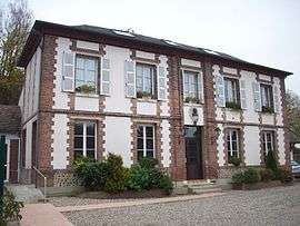 The town hall in Saint-Denis-le-Thiboult | |
Location of Saint-Denis-le-Thiboult 
| |
 Saint-Denis-le-Thiboult  Saint-Denis-le-Thiboult | |
| Coordinates: 49°27′36″N 1°21′50″E | |
| Country | France |
| Region | Normandy |
| Department | Seine-Maritime |
| Arrondissement | Rouen |
| Canton | Le Mesnil-Esnard |
| Government | |
| • Mayor | Bernard Mainemard |
| Area 1 | 10.25 km2 (3.96 sq mi) |
| Population (2017-01-01)[1] | 504 |
| • Density | 49/km2 (130/sq mi) |
| Time zone | UTC+01:00 (CET) |
| • Summer (DST) | UTC+02:00 (CEST) |
| INSEE/Postal code | 76573 /76116 |
| Elevation | 56–161 m (184–528 ft) (avg. 65 m or 213 ft) |
| 1 French Land Register data, which excludes lakes, ponds, glaciers > 1 km2 (0.386 sq mi or 247 acres) and river estuaries. | |
Geography
A farming village situated in the Pays de Bray between Ry and Vascœuil, some 12 miles (19 km) east of Rouen near the junction of the D12 and the N31 roads. The small river Crevon, a tributary of the Andelle, flows through the commune.
Population
| 1962 | 1968 | 1975 | 1982 | 1990 | 1999 | 2006 |
|---|---|---|---|---|---|---|
| 294 | 295 | 341 | 409 | 471 | 490 | 516 |
| Starting in 1962: Population without duplicates | ||||||
Places of interest
- The church of St. Denis, dating from the thirteenth century.
- A sixteenth-century manorhouse with a dovecote.
- The chateau of Ventes.
- A feudal motte and walls.
References
- "Populations légales 2017". INSEE. Retrieved 6 January 2020.
| Wikimedia Commons has media related to Saint-Denis-le-Thiboult. |
| Authority control |
|
|---|
This article is issued from Wikipedia. The text is licensed under Creative Commons - Attribution - Sharealike. Additional terms may apply for the media files.