Saint-Martin-Osmonville
Saint-Martin-Osmonville is a commune in the Seine-Maritime department in the Normandy region in northern France.
Saint-Martin-Osmonville | |
|---|---|
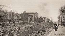 The railway station at St-Martin-Osmonville around 1900 | |
Location of Saint-Martin-Osmonville 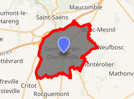
| |
 Saint-Martin-Osmonville  Saint-Martin-Osmonville | |
| Coordinates: 49°38′25″N 1°18′01″E | |
| Country | France |
| Region | Normandy |
| Department | Seine-Maritime |
| Arrondissement | Dieppe |
| Canton | Neufchâtel-en-Bray |
| Intercommunality | CC Bray-Eawy |
| Government | |
| • Mayor (2008–2014) | Carole Haimonet |
| Area 1 | 21.34 km2 (8.24 sq mi) |
| Population (2017-01-01)[1] | 1,171 |
| • Density | 55/km2 (140/sq mi) |
| Time zone | UTC+01:00 (CET) |
| • Summer (DST) | UTC+02:00 (CEST) |
| INSEE/Postal code | 76621 /76680 |
| Elevation | 110–207 m (361–679 ft) (avg. 176 m or 577 ft) |
| 1 French Land Register data, which excludes lakes, ponds, glaciers > 1 km2 (0.386 sq mi or 247 acres) and river estuaries. | |
The inhabitants of the town of Saint-Martin-Osmonville are "St. Martin, St. Martinaises."[2]
Geography
A farming village comprising several hamlets, situated by the banks of the Varenne river in the Pays de Bray, at the junction of the D38, D41, D154 and the D928 roads, some 30 miles (48 km) southeast of Dieppe. Junction 11 of the A29 autoroute with the A28 autoroute forms much of the northwest border of the commune.
Population
| 1962 | 1968 | 1975 | 1982 | 1990 | 1999 | 2006 |
|---|---|---|---|---|---|---|
| 688 | 708 | 737 | 756 | 775 | 824 | 1075 |
| Starting in 1962: Population without duplicates | ||||||
Places of interest
- The church of St. Martin, dating from the fifteenth century.
- The thirteenth-century church of St. Martin in the hamlet of La Prée.
References
- "Populations légales 2017". INSEE. Retrieved 6 January 2020.
- "Communes"
| Wikimedia Commons has media related to Saint-Martin-Osmonville. |
| Authority control |
|
|---|
This article is issued from Wikipedia. The text is licensed under Creative Commons - Attribution - Sharealike. Additional terms may apply for the media files.