Mesnil-Mauger
Mesnil-Mauger is a commune in the Seine-Maritime department in the Normandy region in northern France.
Mesnil-Mauger | |
|---|---|
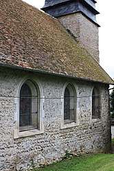 The church in Mesnil-Mauger | |
Location of Mesnil-Mauger 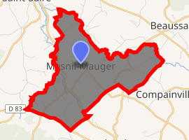
| |
 Mesnil-Mauger  Mesnil-Mauger | |
| Coordinates: 49°40′23″N 1°31′07″E | |
| Country | France |
| Region | Normandy |
| Department | Seine-Maritime |
| Arrondissement | Dieppe |
| Canton | Gournay-en-Bray |
| Intercommunality | CC 4 rivières |
| Government | |
| • Mayor (2001–2008) | Claude Lefebvre |
| Area 1 | 8.28 km2 (3.20 sq mi) |
| Population (2017-01-01)[1] | 247 |
| • Density | 30/km2 (77/sq mi) |
| Time zone | UTC+01:00 (CET) |
| • Summer (DST) | UTC+02:00 (CEST) |
| INSEE/Postal code | 76432 /76440 |
| Elevation | 101–202 m (331–663 ft) (avg. 160 m or 520 ft) |
| 1 French Land Register data, which excludes lakes, ponds, glaciers > 1 km2 (0.386 sq mi or 247 acres) and river estuaries. | |
Geography
A farming village situated by the banks of the Béthune River in the Pays de Bray, some 32 miles (51 km) southeast of Dieppe at the junction of the D120, the D102 and the D1314 roads.
Population
| 1962 | 1968 | 1975 | 1982 | 1990 | 1999 | 2006 |
|---|---|---|---|---|---|---|
| 293 | 239 | 213 | 190 | 207 | 223 | 235 |
| Starting in 1962: Population without duplicates | ||||||
Places of interest
- The church of St.Maur in the hamlet of Trefforest, dating from the eleventh century.
- The church of Notre-Dame, also dating from the eleventh century.
References
- "Populations légales 2017". INSEE. Retrieved 6 January 2020.
| Wikimedia Commons has media related to Mesnil-Mauger. |
| Authority control |
|
|---|
This article is issued from Wikipedia. The text is licensed under Creative Commons - Attribution - Sharealike. Additional terms may apply for the media files.