Saint-Aubin-de-Crétot
Saint-Aubin-de-Crétot is a commune in the Seine-Maritime department in the Normandy region in northern France.
Saint-Aubin-de-Crétot | |
|---|---|
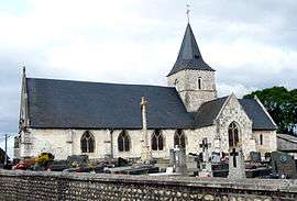 The church in Saint-Aubin-de-Crétot | |
 Coat of arms | |
Location of Saint-Aubin-de-Crétot 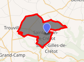
| |
 Saint-Aubin-de-Crétot  Saint-Aubin-de-Crétot | |
| Coordinates: 49°34′12″N 0°38′22″E | |
| Country | France |
| Region | Normandy |
| Department | Seine-Maritime |
| Arrondissement | Rouen |
| Canton | Notre-Dame-de-Gravenchon |
| Intercommunality | CA Caux vallée de Seine |
| Government | |
| • Mayor | Jacques Lelouard |
| Area 1 | 4.73 km2 (1.83 sq mi) |
| Population (2017-01-01)[1] | 522 |
| • Density | 110/km2 (290/sq mi) |
| Time zone | UTC+01:00 (CET) |
| • Summer (DST) | UTC+02:00 (CEST) |
| INSEE/Postal code | 76559 /76190 |
| Elevation | 80–154 m (262–505 ft) (avg. 147 m or 482 ft) |
| 1 French Land Register data, which excludes lakes, ponds, glaciers > 1 km2 (0.386 sq mi or 247 acres) and river estuaries. | |
Geography
A farming village situated in the Pays de Caux, some 25 miles (40 km) northwest of Rouen near the junction of the D34 and the D40 roads.
Heraldry
Arms of Saint-Aubin-de-Crétot |
The arms of Saint-Aubin-de-Crétot are blazoned : Argent, on a chevron azure between 2 mallets and a rose gules, an escallop Or. |
Population
| 1962 | 1968 | 1975 | 1982 | 1990 | 1999 | 2006 |
|---|---|---|---|---|---|---|
| 189 | 209 | 211 | 374 | 465 | 474 | 519 |
| Starting in 1962: Population without duplicates | ||||||
Places of interest
- The church of St. Aubin, dating from the twelfth century.
- The seventeenth-century chateau.
References
- "Populations légales 2017". INSEE. Retrieved 6 January 2020.
External links
| Wikimedia Commons has media related to Saint-Aubin-de-Crétot. |
- Saint-Aubin-de-Crétot on the Quid website (in French)
| Authority control |
|
|---|
This article is issued from Wikipedia. The text is licensed under Creative Commons - Attribution - Sharealike. Additional terms may apply for the media files.