Mont-Cauvaire
Mont-Cauvaire is a commune in the Seine-Maritime department in the Normandy region in northern France.
Mont-Cauvaire | |
|---|---|
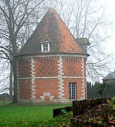 The dovecote of the Domaine du Fossé | |
.svg.png) Coat of arms | |
Location of Mont-Cauvaire 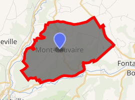
| |
 Mont-Cauvaire  Mont-Cauvaire | |
| Coordinates: 49°34′18″N 1°06′38″E | |
| Country | France |
| Region | Normandy |
| Department | Seine-Maritime |
| Arrondissement | Rouen |
| Canton | Bois-Guillaume |
| Government | |
| • Mayor | Emmanuel De Bailliencourt |
| Area 1 | 9.02 km2 (3.48 sq mi) |
| Population (2017-01-01)[1] | 741 |
| • Density | 82/km2 (210/sq mi) |
| Time zone | UTC+01:00 (CET) |
| • Summer (DST) | UTC+02:00 (CEST) |
| INSEE/Postal code | 76443 /76690 |
| Elevation | 65–176 m (213–577 ft) (avg. 175 m or 574 ft) |
| 1 French Land Register data, which excludes lakes, ponds, glaciers > 1 km2 (0.386 sq mi or 247 acres) and river estuaries. | |
Geography
A farming village, situated along the banks of the Cailly River in the Pays de Caux, some 10 miles (16 km) north of Rouen on the D3 road.
Heraldry
Arms of Mont-Cauvaire |
The arms of Mont-Cauvaire are blazoned : Gules, 2 fesses wavy abased, with a triple-peaked mount argent over them, in chief a leopard Or armed sable, langued gules, holding a latin cross bendwise sable. |
Population
| 1962 | 1968 | 1975 | 1982 | 1990 | 1999 | 2006 |
|---|---|---|---|---|---|---|
| 411 | 451 | 471 | 557 | 603 | 566 | 614 |
| Starting in 1962: Population without duplicates | ||||||
Places of interest
- The church of St.Martin, dating from the nineteenth century.
- A sixteenth century sandstone cross.
- The seventeenth century Château du Rombosc, with its chapel, and parkland.
- The Château du Fossé, dating from the seventeenth century.
- The eighteenth century Pavillon de La Tourelle and its parkland.
- Two dovecotes and a communal oven.
References
- "Populations légales 2017". INSEE. Retrieved 6 January 2020.
| Wikimedia Commons has media related to Mont-Cauvaire. |
| Authority control |
|
|---|
This article is issued from Wikipedia. The text is licensed under Creative Commons - Attribution - Sharealike. Additional terms may apply for the media files.