Rieux, Seine-Maritime
Rieux is a commune in the Seine-Maritime department in the Normandy region in northern France.
Rieux | |
|---|---|
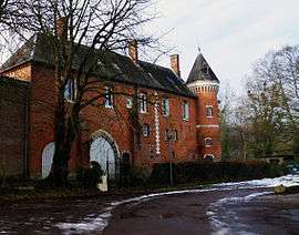 The manor in Rieux | |
.svg.png) Coat of arms | |
Location of Rieux 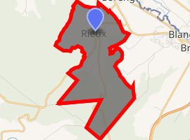
| |
 Rieux  Rieux | |
| Coordinates: 49°56′10″N 1°34′55″E | |
| Country | France |
| Region | Normandy |
| Department | Seine-Maritime |
| Arrondissement | Dieppe |
| Canton | Eu |
| Intercommunality | CC Aumale - Blangy-sur-Bresle |
| Government | |
| • Mayor | Christian Roussel |
| Area 1 | 7.09 km2 (2.74 sq mi) |
| Population (2017-01-01)[1] | 632 |
| • Density | 89/km2 (230/sq mi) |
| Time zone | UTC+01:00 (CET) |
| • Summer (DST) | UTC+02:00 (CEST) |
| INSEE/Postal code | 76528 /76340 |
| Elevation | 61–209 m (200–686 ft) (avg. 110 m or 360 ft) |
| 1 French Land Register data, which excludes lakes, ponds, glaciers > 1 km2 (0.386 sq mi or 247 acres) and river estuaries. | |
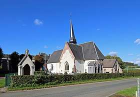
St Martin and Bartholomeus church in Rieux
Geography
A forestry and farming village situated in the Pays de Bray at the junction of the D149 with the D407 road, some 22 miles (35 km) east of Dieppe.
Heraldry
Arms of Rieux |
The arms of Rieux are blazoned : Or, on a fess wavy azure between a demi-lion issuant from the fess and, in fess a rose between 2 mallets gules, a sword [fesswise] argent. |
Population
| 1962 | 1968 | 1975 | 1982 | 1990 | 1999 | 2006 |
|---|---|---|---|---|---|---|
| 362 | 407 | 415 | 417 | 475 | 576 | 660 |
| Starting in 1962: Population without duplicates | ||||||
Places of interest
- The church of St. Martin & St. Barthélemy, dating from the sixteenth century.
- A fifteenth century brick-built manorhouse.
References
- "Populations légales 2017". INSEE. Retrieved 6 January 2020.
External links
| Wikimedia Commons has media related to Rieux (Seine-Maritime). |
- Rieux on the Quid website (in French)
| Authority control |
|
|---|
This article is issued from Wikipedia. The text is licensed under Creative Commons - Attribution - Sharealike. Additional terms may apply for the media files.