Saint-Aubin-Routot
Saint-Aubin-Routot is a commune in the Seine-Maritime department in the Normandy region in northern France.
Saint-Aubin-Routot | |
|---|---|
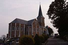 The church in Saint-Aubin-Routot | |
 Coat of arms | |
Location of Saint-Aubin-Routot 
| |
 Saint-Aubin-Routot  Saint-Aubin-Routot | |
| Coordinates: 49°31′26″N 0°19′36″E | |
| Country | France |
| Region | Normandy |
| Department | Seine-Maritime |
| Arrondissement | Le Havre |
| Canton | Saint-Romain-de-Colbosc |
| Intercommunality | Le Havre Seine Métropole |
| Area 1 | 6.63 km2 (2.56 sq mi) |
| Population (2017-01-01)[1] | 1,900 |
| • Density | 290/km2 (740/sq mi) |
| Time zone | UTC+01:00 (CET) |
| • Summer (DST) | UTC+02:00 (CEST) |
| INSEE/Postal code | 76563 /76430 |
| Elevation | 19–122 m (62–400 ft) (avg. 110 m or 360 ft) |
| 1 French Land Register data, which excludes lakes, ponds, glaciers > 1 km2 (0.386 sq mi or 247 acres) and river estuaries. | |
Geography
It is a farming village in the Pays de Caux, situated some 12 miles (19 km) east of Le Havre, on the D01515 road, in the valley of the Bolbec river.
Heraldry
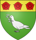
Arms of Saint-Aubin-Routot |
The arms of Saint-Aubin-Routot are blazoned : Vert, a dove holding in its beak an olive branch argent, and on a chief Or, 3 roses gules. |
Population
| 1962 | 1968 | 1975 | 1982 | 1990 | 1999 | 2006 |
|---|---|---|---|---|---|---|
| 645 | 646 | 941 | 1015 | 1077 | 1118 | 1287 |
| Starting in 1962: Population without duplicates | ||||||
Places of interest
- The church of St. Aubin, dating from the nineteenth century.
- The 700-year-old yewtree by the church.
References
- "Populations légales 2017". INSEE. Retrieved 6 January 2020.
| Wikimedia Commons has media related to Saint-Aubin-Routot. |
| Authority control |
|
|---|
This article is issued from Wikipedia. The text is licensed under Creative Commons - Attribution - Sharealike. Additional terms may apply for the media files.