Rocquefort
Rocquefort is a commune in the Seine-Maritime department in the Normandy region in northern France.
Rocquefort | |
|---|---|
 Coat of arms | |
Location of Rocquefort 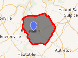
| |
 Rocquefort  Rocquefort | |
| Coordinates: 49°40′00″N 0°41′50″E | |
| Country | France |
| Region | Normandy |
| Department | Seine-Maritime |
| Arrondissement | Rouen |
| Canton | Saint-Valery-en-Caux |
| Intercommunality | Cœur de Caux |
| Area 1 | 5.36 km2 (2.07 sq mi) |
| Population (2017-01-01)[1] | 315 |
| • Density | 59/km2 (150/sq mi) |
| Time zone | UTC+01:00 (CET) |
| • Summer (DST) | UTC+02:00 (CEST) |
| INSEE/Postal code | 76531 /76640 |
| Elevation | 76–146 m (249–479 ft) (avg. 130 m or 430 ft) |
| 1 French Land Register data, which excludes lakes, ponds, glaciers > 1 km2 (0.386 sq mi or 247 acres) and river estuaries. | |
Geography
A farming village in the Pays de Caux, situated some 35 miles (56 km) northeast of Le Havre, between the D29 and D131 roads, by the banks of the river Durdent.
Heraldry
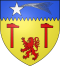
Arms of Rocquefort |
The arms of Rocquefort are blazoned : Or, 2 hammers and a lion gules, and on a chief indented azure, a comet argent. |
Population
| 1962 | 1968 | 1975 | 1982 | 1990 | 1999 | 2006 |
|---|---|---|---|---|---|---|
| 234 | 240 | 209 | 227 | 250 | 270 | 312 |
| Starting in 1962: Population without duplicates | ||||||
Places of interest
External links
| Wikimedia Commons has media related to Rocquefort. |
- Official website (in French)
- Rocquefort on the Quid website (in French)
| Authority control |
|
|---|
This article is issued from Wikipedia. The text is licensed under Creative Commons - Attribution - Sharealike. Additional terms may apply for the media files.