Saint-Vigor-d'Ymonville
Saint-Vigor-d’Ymonville is a commune in the Seine-Maritime department in the Normandy region in northern France.
Saint-Vigor-d’Ymonville | |
|---|---|
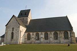 The church in Saint-Vigor-d'Ymonville | |
Location of Saint-Vigor-d’Ymonville 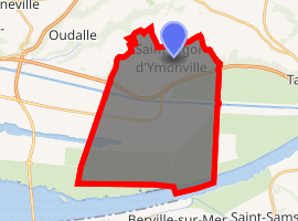
| |
 Saint-Vigor-d’Ymonville  Saint-Vigor-d’Ymonville | |
| Coordinates: 49°29′46″N 0°21′42″E | |
| Country | France |
| Region | Normandy |
| Department | Seine-Maritime |
| Arrondissement | Le Havre |
| Canton | Saint-Romain-de-Colbosc |
| Intercommunality | Le Havre Seine Métropole |
| Area 1 | 29.43 km2 (11.36 sq mi) |
| Population (2017-01-01)[1] | 1,130 |
| • Density | 38/km2 (99/sq mi) |
| Time zone | UTC+01:00 (CET) |
| • Summer (DST) | UTC+02:00 (CEST) |
| INSEE/Postal code | 76657 /76430 |
| Elevation | 0–124 m (0–407 ft) (avg. 112 m or 367 ft) |
| 1 French Land Register data, which excludes lakes, ponds, glaciers > 1 km2 (0.386 sq mi or 247 acres) and river estuaries. | |
Geography
A farming and light industrial village, by the banks of the Seine, in the Pays de Caux, situated some 12 miles (19 km) east of Le Havre, at the junction of the D10 and D112 roads. The commune has two distinct parts: the north contains the village, farms and woodland, the south, separated by the A131 autoroute and the canal de Tancarville, has some port activity, quarrying and reclaimed marshland
Population
| 1962 | 1968 | 1975 | 1982 | 1990 | 1999 | 2006 |
|---|---|---|---|---|---|---|
| 567 | 571 | 647 | 757 | 835 | 859 | 971 |
| Starting in 1962: Population without duplicates | ||||||
Places of interest
- The twelfth-century church of St. Vigor.
- The ruins of the mediaeval priory.
External links
| Wikimedia Commons has media related to Saint-Vigor-d'Ymonville. |
- Saint-Vigor-d’Ymonville on the Quid website (in French)
| Authority control |
|
|---|
This article is issued from Wikipedia. The text is licensed under Creative Commons - Attribution - Sharealike. Additional terms may apply for the media files.