Saint-Germain-d'Étables
Saint-Germain-d’Étables is a commune in the Seine-Maritime department in the Normandy region in northern France.
Saint-Germain-d’Étables | |
|---|---|
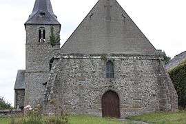 The church in Saint-Germain-d'Étables | |
 Coat of arms | |
Location of Saint-Germain-d’Étables 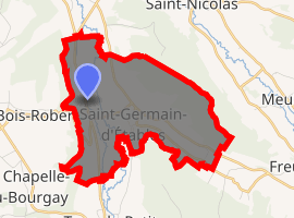
| |
 Saint-Germain-d’Étables  Saint-Germain-d’Étables | |
| Coordinates: 49°50′14″N 1°11′00″E | |
| Country | France |
| Region | Normandy |
| Department | Seine-Maritime |
| Arrondissement | Dieppe |
| Canton | Luneray |
| Intercommunality | CC Terroir de Caux |
| Government | |
| • Mayor | Michel Chardonnet |
| Area 1 | 7.26 km2 (2.80 sq mi) |
| Population (2017-01-01)[1] | 263 |
| • Density | 36/km2 (94/sq mi) |
| Time zone | UTC+01:00 (CET) |
| • Summer (DST) | UTC+02:00 (CEST) |
| INSEE/Postal code | 76582 /76590 |
| Elevation | 14–140 m (46–459 ft) (avg. 28 m or 92 ft) |
| 1 French Land Register data, which excludes lakes, ponds, glaciers > 1 km2 (0.386 sq mi or 247 acres) and river estuaries. | |
Geography
A farming village situated by the banks of the Varenne River in the Pays de Caux at the junction of the D107 with the D98 road, some 7 miles (11 km) south of Dieppe.
Heraldry
Arms of Saint-Germain-d'Étables |
The arms of Saint-Germain-d'Étables are blazoned : Or, fretty gules, on an inescutcheon azure a lion and in chief 2 escallops argent. |
Population
| 1962 | 1968 | 1975 | 1982 | 1990 | 1999 | 2006 |
|---|---|---|---|---|---|---|
| 163 | 175 | 172 | 241 | 324 | 298 | 364 |
| Starting in 1962: Population without duplicates | ||||||
Places of interest
- The church of Notre-Dame, dating from the sixteenth century.
References
- "Populations légales 2017". INSEE. Retrieved 6 January 2020.
External links
| Wikimedia Commons has media related to Saint-Germain-d'Étables. |
- Saint-Germain-d’Étables on the Quid website (in French)
| Authority control |
|
|---|
This article is issued from Wikipedia. The text is licensed under Creative Commons - Attribution - Sharealike. Additional terms may apply for the media files.