YO postcode area
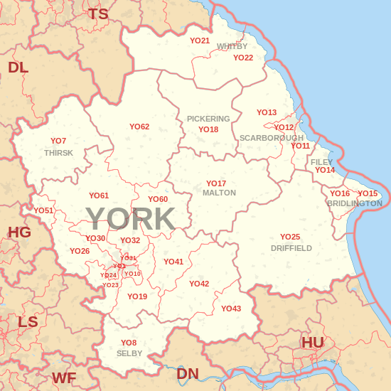
The YO postcode area, also known as the York postcode area,[2] is a group of 30 postcode districts in Yorkshire, England, within ten post towns. These cover most of North Yorkshire (including York, Scarborough, Pickering, Selby, Thirsk, Malton, Filey and Whitby) and the northern part of the East Riding of Yorkshire (including Bridlington and Driffield).
| York postcode area | |
|---|---|
 YO | |
| Postcode area | YO |
| Postcode area name | York |
| Post towns | 10 |
| Postcode districts | 37 |
| Postcode sectors | 161 |
| Postcodes (live) | 18,600 |
| Postcodes (total) | 34,239 |
| Statistics as at May 2020[1] | |
Coverage
The approximate coverage of the postcode districts:
| Postcode district | Post town | Coverage | Local authority area(s) |
|---|---|---|---|
| YO1 | YORK | City Centre | City of York Council |
| YO7 | THIRSK | Dalton, Hambleton, Thirsk, Topcliffe | North Yorkshire County Council |
| YO8 | SELBY | Barlby, Brayton, Bubwith, Cawood, Camblesforth, Drax, Selby, Thorpe Willoughby | North Yorkshire County Council |
| YO10 | YORK | Fishergate, Fulford, Heslington, Osbaldwick, Tang Hall | City of York Council |
| YO11 | SCARBOROUGH | Cayton, Eastfield | North Yorkshire County Council |
| YO12 | SCARBOROUGH | Seamer | North Yorkshire County Council |
| YO13 | SCARBOROUGH | North Yorkshire County Council | |
| YO14 | FILEY | North Yorkshire County Council | |
| YO15 | BRIDLINGTON | Bridlington, Bempton, Buckton, Carnaby, Flamborough, Fraisthorpe, Sewerby, Wilsthorpe | East Riding of Yorkshire |
| YO16 | BRIDLINGTON | Bridlington, Bempton, Bessingby, Boynton, Buckton, Carnaby, Grindale, Sewerby | East Riding of Yorkshire |
| YO17 | MALTON | Norton | North Yorkshire County Council |
| YO18 | PICKERING | Pickering, Thornton-le-Dale | North Yorkshire County Council |
| YO19 | YORK | Dunnington, Escrick, Wheldrake, Murton, Riccall, Stillingfleet, Warthill | City of York Council, North Yorkshire County Council |
| YO21 | WHITBY | Whitby, Westerdale | North Yorkshire County Council |
| YO22 | WHITBY | Robin Hood's Bay | North Yorkshire County Council |
| YO23 | YORK | South Bank, Bishopthorpe, Copmanthorpe, Rufforth | City of York Council, North Yorkshire County Council |
| YO24 | YORK | Acomb, Dringhouses, Woodthorpe | City of York Council |
| YO25 | DRIFFIELD | Driffield | East Riding of Yorkshire |
| YO26 | YORK | Acomb, Leeman Road Area, Upper Poppleton, Nether Poppleton, Green Hammerton | City of York Council, North Yorkshire County Council |
| YO30 | YORK | Bootham, Clifton, Skelton, Linton-on-Ouse | City of York Council, North Yorkshire County Council |
| YO31 | YORK | Heworth, Huntington (South), The Groves, Layerthorpe | City of York Council |
| YO32 | YORK | Haxby, Huntington (North), Wigginton, New Earswick, Stockton-on-the-Forest, Strensall | City of York Council |
| YO41 | YORK | Elvington, Full Sutton, Stamford Bridge, Sutton upon Derwent, Wilberfoss | |
| YO42 | YORK | Pocklington, Barmby Moor, Melbourne, Seaton Ross | East Riding of Yorkshire |
| YO43 | YORK | Market Weighton, Holme-on-Spalding-Moor | East Riding of Yorkshire |
| YO51 | YORK | Boroughbridge | North Yorkshire County Council |
| YO60 | YORK | Sheriff Hutton | |
| YO61 | YORK | Easingwold | North Yorkshire County Council |
| YO62 | YORK | Helmsley, Kirkbymoorside, Nawton | North Yorkshire County Council |
| YO90 | YORK | Large offices in Rougier Street and Wellington Row in York |
Map
gollark: Also also, poor performance.
gollark: Also forced updates, giant EULA, broken search, and general lack of configurability.
gollark: <@!111608748027445248> Don't forget the telemetry!
gollark: Well, it's *quite* bad.
gollark: When he says "YOU WILL REGRET THIS", does that mean he's going to try and sabotage roads to get more money or something?
References
- "ONS Postcode Directory Version Notes" (ZIP). National Statistics Postcode Products. Office for National Statistics. May 2020. Table 2. Retrieved 19 June 2020. Coordinates from mean of unit postcode points, "Code-Point Open". OS OpenData. Ordnance Survey. February 2012. Retrieved 21 April 2012.
- Royal Mail, Address Management Guide, (2004)
External links
This article is issued from Wikipedia. The text is licensed under Creative Commons - Attribution - Sharealike. Additional terms may apply for the media files.