ZE postcode area
The ZE postcode area, also known as the Lerwick postcode area,[2] is a group of 3 postcode districts covering around 650 live postcodes in the Shetland Islands in Scotland. The letters in the postcode are derived from Zetland, the name for the council area until 1975.
| Lerwick postcode area | |
|---|---|
 ZE | |
| Postcode area | ZE |
| Postcode area name | Lerwick |
| Post towns | 1 |
| Postcode districts | 3 |
| Postcode sectors | 4 |
| Postcodes (live) | 650 |
| Postcodes (total) | 749 |
| Statistics as at May 2020[1] | |
Coverage
The approximate coverage of the postcode districts:
| Postcode district | Post town | Coverage | Local authority area |
|---|---|---|---|
| ZE1 | SHETLAND | Lerwick, Scalloway | Shetland Islands Council |
| ZE2 | SHETLAND | Most of Mainland, Yell, Unst, Fetlar, Foula, Fair Isle | Shetland Islands Council |
| ZE3 | SHETLAND | Virkie | Shetland Islands Council |
Map
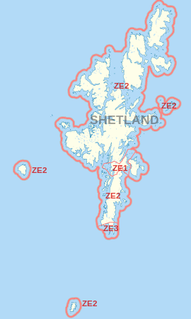
ZE postcode area map, showing postcode districts in red and the post town in grey text.
The KW postcode area is situated to the southwest.
gollark: Very shiny.
gollark: I mean, I don't go around thinking about lizard reproduction very often.
gollark: A sterile lizard, probably.
gollark: Although in our English lessons I generally ended up having time to reread the book a fwe times while we were doing it. So boring.
gollark: I never actually did do that. It probably would have saved time, in retrospect.
See also
- Postcode Address File
- List of postcode areas in the United Kingdom
- Extreme points of the United Kingdom
References
- "ONS Postcode Directory Version Notes" (ZIP). National Statistics Postcode Products. Office for National Statistics. May 2020. Table 2. Retrieved 19 June 2020. Coordinates from mean of unit postcode points, "Code-Point Open". OS OpenData. Ordnance Survey. February 2012. Retrieved 21 April 2012.
- Royal Mail, Address Management Guide, (2004)
External List
This article is issued from Wikipedia. The text is licensed under Creative Commons - Attribution - Sharealike. Additional terms may apply for the media files.