DE postcode area
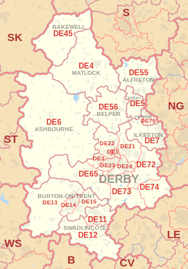
The DE postcode area, also known as the Derby postcode area,[2] is a group of 23 postcode districts in central England, which are subdivisions of 11 post towns. These postcode districts cover south and central Derbyshire (including Derby, Alfreton, Ashbourne, Bakewell, Belper, Heanor, Ilkeston, Matlock, Ripley and Swadlincote), parts of east Staffordshire (including Burton upon Trent) and north-west Leicestershire, and very small parts of Nottinghamshire.
| Derby postcode area | |
|---|---|
 DE | |
| Postcode area | DE |
| Postcode area name | Derby |
| Post towns | 11 |
| Postcode districts | 25 |
| Postcode sectors | 129 |
| Postcodes (live) | 17,235 |
| Postcodes (total) | 30,008 |
| Statistics as at May 2020[1] | |
Coverage
The approximate coverage of the postcode districts:
Map
gollark: You say I can experiment too, so... how, exactly?
gollark: Can you actually *give* one instead of just continuously pointing people toward other stuff?
gollark: How do you suggest I go around demonstrating this whole "electric universe" thing conveniently, then?
gollark: Although if you intend to destroy people by using physics which does not actually work, I'll be fine.
gollark: Destroying people would be mean, don't do that.
References
- "ONS Postcode Directory Version Notes" (ZIP). National Statistics Postcode Products. Office for National Statistics. May 2020. Table 2. Retrieved 19 June 2020. Coordinates from mean of unit postcode points, "Code-Point Open". OS OpenData. Ordnance Survey. February 2012. Retrieved 21 April 2012.
- Royal Mail, Address Management Guide, (2004)
External links
This article is issued from Wikipedia. The text is licensed under Creative Commons - Attribution - Sharealike. Additional terms may apply for the media files.