ML postcode area
The ML postcode area, also known as the Motherwell postcode area,[2] is a group of twelve postcode districts in south-central Scotland, within twelve post towns. These cover most of North Lanarkshire (including Motherwell, Wishaw, Bellshill, Coatbridge, Airdrie and Shotts) and South Lanarkshire (including Hamilton, Carluke, Larkhall, Strathaven, Lanark and Biggar), plus very small parts of West Lothian, the Scottish Borders and Dumfries and Galloway.
| Motherwell postcode area | |
|---|---|
 ML | |
| Postcode area | ML |
| Postcode area name | Motherwell |
| Post towns | 12 |
| Postcode districts | 12 |
| Postcode sectors | 55 |
| Postcodes (live) | 9,653 |
| Postcodes (total) | 11,712 |
| Statistics as at May 2020[1] | |
Coverage
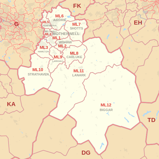
The approximate coverage of the postcode districts:
| Postcode district | Post town | Coverage | Local authority area(s) |
|---|---|---|---|
| ML1 | MOTHERWELL | Motherwell, Carfin, Cleland, Hareshaw, Holytown, New Stevenston, Newarthill, Newhouse | North Lanarkshire |
| ML2 | WISHAW | Wishaw, Bonkle, Bogside, Garrion Bridge, Morningside, Overtown, Waterloo, Newmains | North Lanarkshire, South Lanarkshire |
| ML3 | HAMILTON | Hamilton, Ferniegair, Limekilnburn, Quarter | South Lanarkshire, North Lanarkshire |
| ML4 | BELLSHILL | Bellshill, Orbiston, Mossend | North Lanarkshire |
| ML5 | COATBRIDGE | Coatbridge, Annathill, Glenboig | North Lanarkshire |
| ML6 | AIRDRIE | Airdrie, Calderbank, Caldercruix, Chapelhall, Forrestfield, Gartness, Glenmavis, Greengairs, Plains, Riggend, Stand, Wattston | North Lanarkshire |
| ML7 | SHOTTS | Shotts, Allanton, Eastfield, Harthill, Hartwood, Salsburgh, Greenrigg | North Lanarkshire, West Lothian |
| ML8 | CARLUKE | Carluke, Kilncazdow, Law | South Lanarkshire |
| ML9 | LARKHALL | Larkhall, Netherburn, Stonehouse, Ashgill | South Lanarkshire |
| ML10 | STRATHAVEN | Strathaven, Caldermill, Chapelton, Drumclog, Glassford, Sandford, Gilmourton, West Dykes Farm | South Lanarkshire |
| ML11 | LANARK | Lanark, Auchenheath, Blackwood, Coalburn, Crossford, Hazelbank, Kirkfieldbank, Kirkmuirhill, Lesmahagow | South Lanarkshire |
| ML12 | BIGGAR | Biggar, Broughton, Symington, Wanlockhead | South Lanarkshire, Scottish Borders, Dumfries and Galloway |
Map
gollark: No.
gollark: Historical baggage, there are Preludes without this.
gollark: Contraubiquitous lasers enabled.
gollark: No, I'm subject to the constraints of physical reality in this area.
gollark: No, they should be in `/boot`.
References
- "ONS Postcode Directory Version Notes" (ZIP). National Statistics Postcode Products. Office for National Statistics. May 2020. Table 2. Retrieved 19 June 2020. Coordinates from mean of unit postcode points, "Code-Point Open". OS OpenData. Ordnance Survey. February 2012. Retrieved 21 April 2012.
- Royal Mail, Address Management Guide, (2004)
External links
This article is issued from Wikipedia. The text is licensed under Creative Commons - Attribution - Sharealike. Additional terms may apply for the media files.