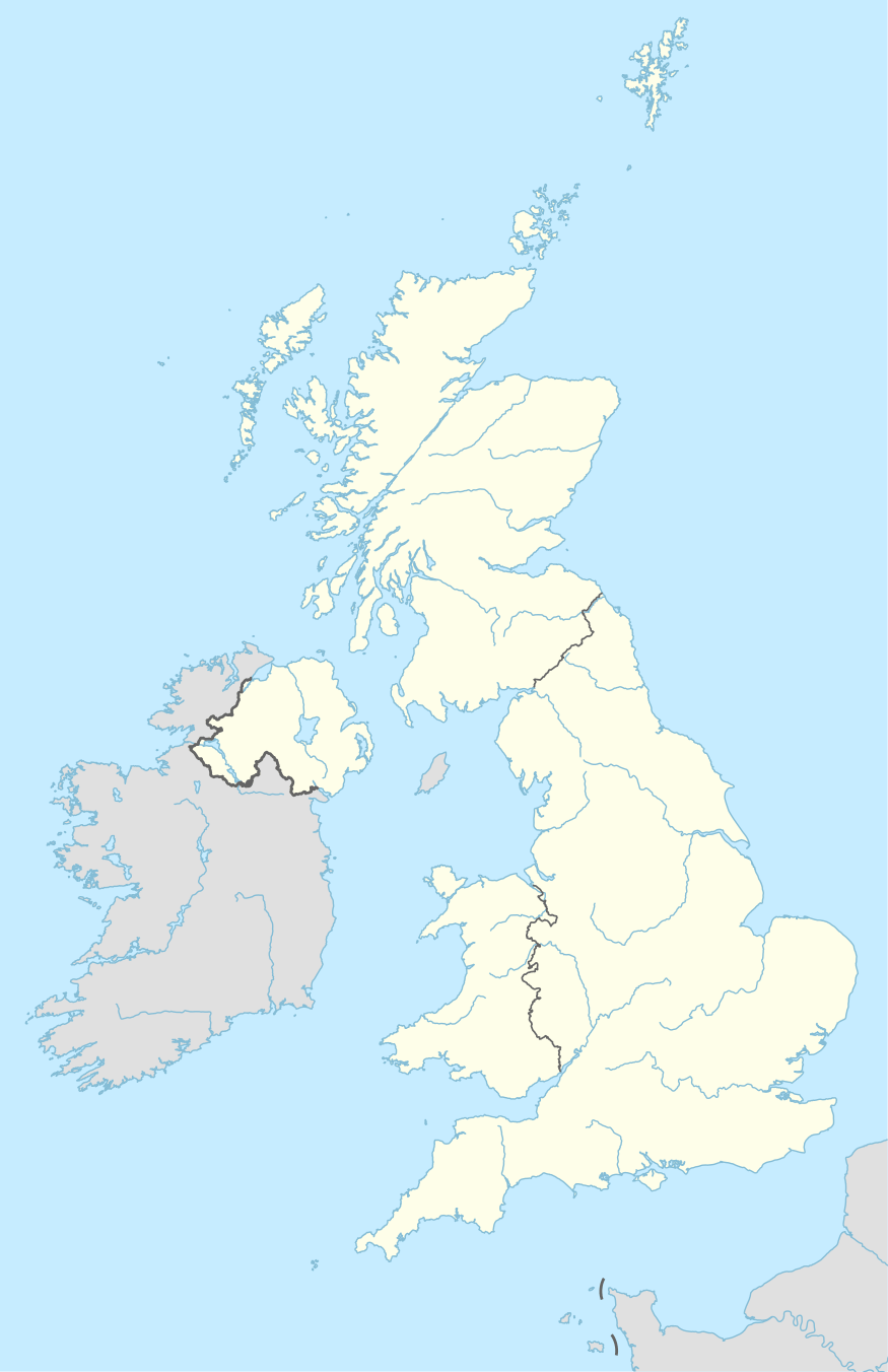
NE postcode area
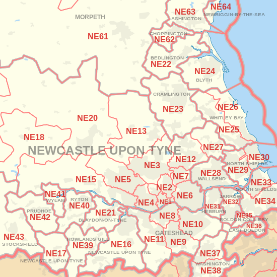
The NE postcode area, also known as the Newcastle upon Tyne postcode area,[2][3][4] is a group of 61 postcode districts in north-east England, within 34 post towns. These cover most of Tyne and Wear (including Newcastle upon Tyne, Gateshead, North Shields, South Shields, Wallsend, Whitley Bay, Hebburn, Jarrow, Washington, Blaydon-on-Tyne, East Boldon, Boldon Colliery, Rowlands Gill and Ryton) and Northumberland (including Blyth, Morpeth, Hexham, Alnwick, Cramlington, Bedlington, Ashington, Prudhoe, Bamburgh, Riding Mill, Choppington, Corbridge, Seahouses, Newbiggin-by-the-Sea, Stocksfield, Haltwhistle, Wylam, Chathill, Belford and Wooler), plus a very small part of northern County Durham.
| Newcastle upon Tyne postcode area | |
|---|---|
 NE | |
| Postcode area | NE |
| Postcode area name | Newcastle upon Tyne |
| Post towns | 34 |
| Postcode districts | 67 |
| Postcode sectors | 230 |
| Postcodes (live) | 33,157 |
| Postcodes (total) | 45,070 |
| Statistics as at May 2020[1] | |
The original NE postal district was created as part of the London postal district in 1858, covering north east London. It was abolished, along with the S postal district covering south London, in 1866..[5]
Coverage
The approximate coverage of the postcode districts:
| Postcode district | Post town | Coverage | Local authority area(s) |
|---|---|---|---|
| NE1 | NEWCASTLE UPON TYNE | City Centre | Newcastle upon Tyne |
| NE2 | NEWCASTLE UPON TYNE | Jesmond, Spital Tongues | Newcastle upon Tyne |
| NE3 | NEWCASTLE UPON TYNE | Gosforth, Fawdon, Kingston Park, Great Park (East) | Newcastle upon Tyne |
| NE4 | NEWCASTLE UPON TYNE | Fenham, Westgate, Wingrove | Newcastle upon Tyne |
| NE5 | NEWCASTLE UPON TYNE | Westerhope, Newcastle West | Newcastle upon Tyne |
| NE6 | NEWCASTLE UPON TYNE | Walker, Byker, Heaton | Newcastle upon Tyne |
| NE7 | NEWCASTLE UPON TYNE | High Heaton, Benton | Newcastle upon Tyne |
| NE8 | GATESHEAD | Gateshead, Bensham | Gateshead |
| NE9 | GATESHEAD | Low Fell, Springwell | Gateshead, Sunderland |
| NE10 | GATESHEAD | Felling, Whitehills Estate, Leam Lane, Pelaw, Bill Quay | Gateshead |
| NE11 | GATESHEAD | Dunston, Metro Centre, Team Valley, Kibblesworth | Gateshead |
| NE12 | NEWCASTLE UPON TYNE | Killingworth, Longbenton | North Tyneside |
| NE13 | NEWCASTLE UPON TYNE | Airport, Wideopen, Dinnington, Great Park (West), Woolsington | Newcastle upon Tyne, North Tyneside |
| NE15 | NEWCASTLE UPON TYNE | Lemington, Throckley, Newburn, Scotswood | Newcastle upon Tyne |
| NE16 | NEWCASTLE UPON TYNE | Whickham, Sunniside, Burnopfield | Gateshead, County Durham |
| NE17 | NEWCASTLE UPON TYNE | Chopwell, Western Chopwell Wood | Gateshead, Northumberland ( lead cottages, Chopwell ) |
| NE18 | NEWCASTLE UPON TYNE | Stamfordham | Northumberland |
| NE19 | NEWCASTLE UPON TYNE | Byrness, Otterburn | Northumberland |
| NE20 | NEWCASTLE UPON TYNE | Ponteland | Northumberland |
| NE21 | BLAYDON-ON-TYNE | Blaydon, Winlaton | Gateshead |
| NE22 | BEDLINGTON | Bedlington, Hartford Bridge | Northumberland |
| NE23 | CRAMLINGTON | Cramlington, Seghill | Northumberland |
| NE24 | BLYTH | Blyth, Newsham, Cowpen, Cambois | Northumberland |
| NE25 | WHITLEY BAY | Monkseaton, Earsdon, New Hartley, Holywell, Seaton Delaval | North Tyneside, Northumberland |
| NE26 | WHITLEY BAY | Whitley Bay, Seaton Sluice | North Tyneside, Northumberland |
| NE27 | NEWCASTLE UPON TYNE | Shiremoor, West Allotment, Backworth, Holystone, Murton Village | North Tyneside |
| NE28 | WALLSEND | Battle Hill, Willington, Wallsend, North Tyne Tunnel | North Tyneside |
| NE29 | NORTH SHIELDS | North Shields, Royal Quays, Billy Mill, New York | North Tyneside |
| NE30 | NORTH SHIELDS | Marden, Tynemouth, Cullercoats | North Tyneside |
| NE31 | HEBBURN | Hebburn | South Tyneside |
| NE32 | JARROW | Jarrow, Fellgate, South Tyne Tunnel | South Tyneside |
| NE33 | SOUTH SHIELDS | Town Centre, Deans, High Shields | South Tyneside |
| NE34 | SOUTH SHIELDS | Harton, Horsley Hill, Marsden, Simonside, Brockley Whins | South Tyneside |
| NE35 | BOLDON COLLIERY | Boldon Colliery | South Tyneside |
| NE36 | EAST BOLDON | East Boldon, West Boldon | South Tyneside |
| NE37 | WASHINGTON | Usworth, Sulgrave, Albany | Sunderland |
| NE38 | WASHINGTON | Town Centre, Oxclose, Fatfield, Harraton | Sunderland |
| NE39 | ROWLANDS GILL | Rowlands Gill, High Spen, Hamsterley Mill, Eastern Chopwell Wood | Gateshead, County Durham |
| NE40 | RYTON | Ryton, Crawcrook, Greenside | Gateshead |
| NE41 | WYLAM | Wylam | Gateshead, Northumberland |
| NE42 | PRUDHOE | Prudhoe | Northumberland |
| NE43 | STOCKSFIELD | Stocksfield | Northumberland |
| NE44 | RIDING MILL | Riding Mill, Broomhaugh | Northumberland |
| NE45 | CORBRIDGE | Corbridge | Northumberland |
| NE46 | HEXHAM | Hexham | Northumberland |
| NE47 | HEXHAM | Acomb, Hexhamshire | Northumberland |
| NE48 | HEXHAM | Falstone, Kielder | Northumberland |
| NE49 | HALTWHISTLE | Haltwhistle | Northumberland |
| NE61 | MORPETH | Morpeth, Tranwell, Clifton, Hepscott, Mitford | Northumberland |
| NE62 | CHOPPINGTON | Scotland Gate, Guidepost, Stakeford, West Sleekburn, Bomarsund | Northumberland |
| NE63 | ASHINGTON | Ashington | Northumberland |
| NE64 | NEWBIGGIN-BY-THE-SEA | Newbiggin-by-the-Sea | Northumberland |
| NE65 | MORPETH | River Coquet | Northumberland |
| NE66 | ALNWICK | Alnwick, Shilbottle | Northumberland |
| NE67 | CHATHILL | Chathill, Beadnell | Northumberland |
| NE68 | SEAHOUSES | Seahouses | Northumberland |
| NE69 | BAMBURGH | Bamburgh | Northumberland |
| NE70 | BELFORD | Belford | Northumberland |
| NE71 | WOOLER | Wooler | Northumberland |
| NE82 | NEWCASTLE UPON TYNE | BT Group[6] | non-geographic |
| NE83 | NEWCASTLE UPON TYNE | BT Group[6] | non-geographic |
| NE85 | NEWCASTLE UPON TYNE | Spark Response Ltd[6] | non-geographic |
| NE88 | NEWCASTLE UPON TYNE | HM Revenue and Customs (Child Benefit Centre)[6] | non-geographic |
| NE92 | GATESHEAD | Department for Work and Pensions (Earlsway)[6] | non-geographic |
| NE98 | NEWCASTLE UPON TYNE | Department for Work and Pensions (Central Office)[6] | non-geographic |
| NE99 | NEWCASTLE UPON TYNE | Locked boxes (Head Post Office)[6] | non-geographic |
Map

References
- "ONS Postcode Directory Version Notes" (ZIP). National Statistics Postcode Products. Office for National Statistics. May 2020. Table 2. Retrieved 19 June 2020. Coordinates from mean of unit postcode points, "Code-Point Open". OS OpenData. Ordnance Survey. February 2012. Retrieved 21 April 2012.
- Royal Mail, Address Management Guide, (2004)
- Manger, Warren (26 August 2014). "40 facts about the postcode to mark 40th anniversary as vital part of daily life". mirror.co.uk. mirror.co.uk. Retrieved 16 March 2018.
- "History of the UK Postcode - Modern Origin". postcodearea.co.uk. postcodearea.co.uk. Retrieved 16 March 2018.
- Reynolds, Laura (October 2016). "Why Is There No NE Or S London Postcode District?". londonist.com. londonist.com. Retrieved 16 December 2017.
- "Non Geographic Codes" (PDF). Royal Mail Address Management Unit. July 2012. Archived from the original (PDF) on 16 September 2012. Retrieved 29 November 2012.
