Escrick
Escrick is a village and civil parish in the Selby District of North Yorkshire, England. It was historically part of the East Riding of Yorkshire until 1974. It is equidistant between Selby and York on what is now the A19 road.
| Escrick | |
|---|---|
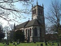
 St Helen's church, Escrick | |
 Escrick Location within North Yorkshire | |
| Population | 1,078 (2011 census)[1] |
| OS grid reference | SE632429 |
| District | |
| Shire county | |
| Region | |
| Country | England |
| Sovereign state | United Kingdom |
| Post town | YORK |
| Postcode district | YO19 |
| Dialling code | 01904 |
| Police | North Yorkshire |
| Fire | North Yorkshire |
| Ambulance | Yorkshire |
| UK Parliament |
|
History and geography
Escrick sits at the southernmost limit of glaciation during the last ice age. When the ice retreated, a deposit known as a "terminal moraine" was left behind, in the form of a ridge. The name "Escrick" may mean "ash ridge", suggesting that the village was first established in an area of Ash.[2]

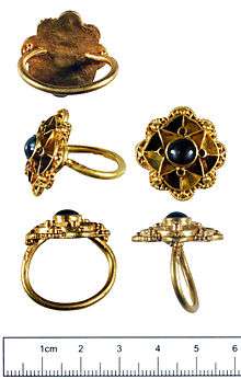
A gold Anglo-Saxon ring (the so-called "Escrick ring") was discovered in a field near Escrick by metal detector in 2009 and was acquired by the Yorkshire Museum for £35,000.[3]
During the medieval period, the village was known as "Ascri" (Ash Ridge), but by 1600 the name Escrick was in use. Escrick was developed as an Estate Village by Sir Henry Thompson who acquired the village and the Hall in 1668. Sir Henry’s great grandson, Beilby Thompson, inherited the Estate in 1742. Under his ownership the village extended towards York and the Church was relocated from beside the Hall to its present site on the York Road (A19). Part of this re-organisation involved stopping the main village street at the gates to the Hall and creating a by-pass which has become the present day A19. The village’s sylvan character also evolved from the time of enclosure when the open land became parkland.
Landmarks
Escrick Hall

A manor-house at Escrick existed in 1323, and in 1557 was called Escrick Hall and was a substantial house of seventeen hearths in the 1670s. The seat of the Lord of the Manor, it was rebuilt in grand style about 1690 with a park of over 450 acres (1.8 km2), and would be much extended and improved in the 18th and 19th centuries.
The house was rebuilt by Henry Thompson (died 1700) c. 1680–90. The house was now two storeys high with basement and attics, and the main front was seven bays long with a central entrance. The building was later re-fronted and raised to three storeys c 1758. In 1763 John Carr of York was employed to design additions to the building adding a range which abuts the north front and extending beyond it to both east and west. A square stable block with four ranges around a central court on the north-east was added. Carr also remodelled the interior of the old house. The mid 19th century was another period of substantial building activity at Escrick. A north-west wing was added in 1846-8, and a north-eastern link to the stables was complete by 1850. Many internal alterations were carried out during the 19th century including the addition of a pump house, laundry, and dairies. The conversion of the house for school use has resulted in some new building, notably a new laboratory block on the north-west, but much of the dormitory and classroom accommodation has been contrived within the old stables and secondary rooms, thankfully leaving the principal rooms intact. The Hall and Escrick estates passed to the present owners, the Forbes Adam family, on the death of Beilby Lawley in 1920. The Hall has been occupied by Queen Margaret's School since 1949 and the park is now operated as a holiday and pleasure park .
Escrick Park is an extensive landscape park with pleasure grounds associated with c.1680 Escrick Hall. Features include: Ionic Temple, 'Menagerie' farm, pond, topiary, woodland walks, and extensive woodland rides which includes a well built cross country horse riding circuit leading through the former 450-acre (1.8 km2) Deer Park in front of the original family house.
The 8,600-acre (35 km2) Escrick Park Estate[4] has developed from what was primarily a family-owned agriculture-based organisation into a management company which is regenerating the Estate's resources. Decline in income from agriculture has led to diversification which now embraces activities such as offering tenancies of residential properties, high quality office and light industrial units, countryside leisure facilities and holiday homes – all while respecting heritage and conservation considerations. The business aims to continue to develop its assets, to leave the estate in good order and develop its business for future generations. The team of eight employees has, through its work, helped to generate over 180 local jobs and greatly enhance the local economy.
Parsonage Hotel
The building that today houses The Parsonage Hotel & Spa dates back to the early 1840s. Retaining many of its original features, it is now a 3-star hotel which features a 2 AA Rosette award winning restaurant and spa facilities, all set in 6 acres of grounds.[5]
Recent history
The village has gained a reputation with being unwelcoming to new residents and for being dominated by Parish Council running its own agenda with scarce consideration to local views.[6] In 2013 a brief respite was achieved when local residents managed to demonstrate that the Parish Council has been acting illegally, and all sitting Councillors were dismissed.[7] However shortly after largely the same Councillors were able to reassert their positions, and continue to pursue their agenda, including proposals to burden residents with over £150,000 of debt for an unnecessary traffic light system.[8]
St Helen's Church
The church of St Helen has stood in its present position since 1783 when Beilby Thompson, then Lord of the Manor, replaced the 13th century church that was once situated to the west of Escrick Hall. The present building, designed in Victorian Gothic style by architect Francis Penrose, was built at the expense of Beilby Lawley in 1857.
The church houses a peal of 12 bells:
| Bell | Weight | Nominal Note | Diameter inches |
Cast year |
Founder Canons |
|---|---|---|---|---|---|
| 1 | 6-3-7 | F# | 29.63" | 1928 | Mears & Stainbank |
| 2 | 6-2-5 | E | 30.00" | 1928 | Mears & Stainbank |
| 3 | 6-1-26 | D# | 30.38" | 1928 | Mears & Stainbank |
| 4 | 6-2-7 | C# | 31.88" | 1928 | Mears & Stainbank |
| 5 | 6-3-19 | B | 32.88" | 1928 | Mears & Stainbank |
| 6 | 7-0-20 | A# | 33.75" | 1928 | Mears & Stainbank |
| 7 | 7-3-26 | G# | 35.88" | 1928 | Mears & Stainbank |
| 8 | 11-0-11 | F# | 39.50" | 1928 | Mears & Stainbank |
| 9 | 16-1-23 | E | 45.00" | 1975 | John Taylor & Co |
| 10 | 17-1-14 | D# | 46.25" | 1928 | Mears & Stainbank |
| 11 | 23-3-24 | C# | 52.25" | 1929 | Mears & Stainbank |
| 12 | 34-2-10 | 509.4B | 59.00" | 1929 | Mears & Stainbank |
| 0extra | 6-3-1 | G# | 2000 | Whitechapel Bell Foundry | |
| 6b | 7-3-17 | A | 35.88" | 1953 | Mears & Stainbank |
Gallery
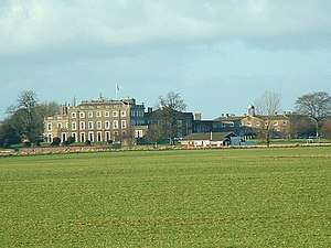
 Queen Margarets Girls School
 The Black Bull Public House
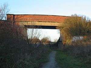
 Cyclepath under the Roadbridge
Notes
- UK Census (2011). "Local Area Report – Escrick Parish (1170217401)". Nomis. Office for National Statistics. Retrieved 24 March 2018.
- "GENUKI (Escrick)".
- "Escrick sapphire ring's mystery history sparks meeting". BBC News. 25 January 2013. Retrieved 11 February 2015.
- Escrick Park Estate
- The Parsonage Hotel & Spa
- "Escrick Voice | Welcome to the site – the place for Escrick residents to communicate with each other about what is happening in the village. To leave a reply you will just have to give a name ( a username which doesn't have to be your real name) and your email address". 24 October 2013. Archived from the original on 24 October 2013. Retrieved 17 July 2019.
- "Parish council operated 'illegally' for two years". York Press. Retrieved 17 July 2019.
- "A19 Consultation". www.escrick.org. Retrieved 17 July 2019.
References
- A History of the County of York East Riding. Volume 3 pp. 17–28 K J Allison (1976)
External links
| Wikimedia Commons has media related to Escrick. |
- Escrick Parish Council
- A detailed history of Escrick
- Escrick Conservation Area
- The ancient parish of Escrick: historical and genealogical information at GENUKI.
- English Nature – For More Information on the terminal morraine – specifically page 46
- Escrick Park
- Champions Case Study
- Forbes Adam/ Thompson/ Lawley (Barons Wenlock) Family of Escrick,1387–1988