CT postcode area
The CT postcode area, also known as the Canterbury postcode area,[2] is a group of 21 postcode districts in South East England, within 13 post towns. These cover much of east Kent, including Canterbury, Dover, Folkestone, Birchington, Broadstairs, Deal, Herne Bay, Hythe, Margate, Ramsgate, Sandwich, Westgate-on-Sea and Whitstable.
| Canterbury postcode area | |
|---|---|
 CT | |
| Postcode area | CT |
| Postcode area name | Canterbury |
| Post towns | 13 |
| Postcode districts | 22 |
| Postcode sectors | 83 |
| Postcodes (live) | 14,846 |
| Postcodes (total) | 19,715 |
| Statistics as at May 2020[1] | |
Coverage
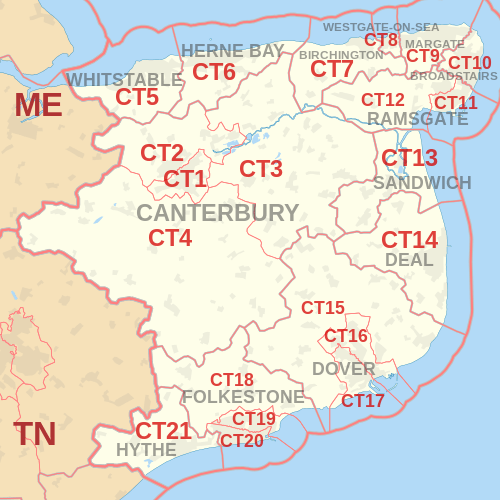
The approximate coverage of the postcode districts:
| Postcode district | Post town | Coverage | Local authority area(s) |
|---|---|---|---|
| CT1 | CANTERBURY | Canterbury (south and city centre) | Canterbury |
| CT2 | CANTERBURY | Canterbury (north), Harbledown, Rough Common, Sturry, Fordwich, Blean, Tyler Hill, Broad Oak, Westbere | Canterbury |
| CT3 | CANTERBURY | Wingham, Hersden | Canterbury, Dover |
| CT4 | CANTERBURY | Canterbury (east and south west), Chartham, Bridge, Nackington, Lower Hardres, Patrixbourne, Bekesbourne, Chartham Hatch, Part of Harbledown and Rough Common | Canterbury |
| CT5 | WHITSTABLE | Whitstable, Seasalter, Tankerton, Chestfield, Swalecliffe, Yorkletts | Canterbury |
| CT6 | HERNE BAY | Herne Bay, Herne, Broomfield, Greenhill, Eddington, Beltinge, Reculver | Canterbury |
| CT7 | BIRCHINGTON | Birchington-on-Sea, St Nicholas-at-Wade, Sarre, Acol | Thanet |
| CT8 | WESTGATE-ON-SEA | Westgate-on-Sea | Thanet |
| CT9 | MARGATE | Margate, Cliftonville, Birchington | Thanet |
| CT10 | BROADSTAIRS | Broadstairs, St Peter's | Thanet |
| CT11 | RAMSGATE | Ramsgate | Thanet |
| CT12 | RAMSGATE | Northwood, Minster-in-Thanet, Cliffsend, Monkton, Manston | Thanet |
| CT13 | SANDWICH | Sandwich, Eastry, Woodnesborough, Great Stonar, Richborough | Dover |
| CT14 | DEAL | Deal, Walmer, Kingsdown, Ringwould, Sholden, Great Mongeham, Worth, Ripple, Tilmanstone, Betteshanger | Dover |
| CT15 | DOVER | Alkham, Lydden, Eythorne, St Margaret's at Cliffe, Elvington | Dover |
| CT16 | DOVER | Dover town centre, Whitfield, Temple Ewell | Dover |
| CT17 | DOVER | Dover (west), Tower Hamlets, River | Dover |
| CT18 | FOLKESTONE | Hawkinge, Lyminge, Etchinghill, Capel-le-Ferne, Densole, Newington | Folkestone and Hythe, Dover |
| CT19 | FOLKESTONE | Folkestone (north), Cheriton | Folkestone and Hythe |
| CT20 | FOLKESTONE | Folkestone (south), Sandgate | Folkestone and Hythe |
| CT21 | HYTHE | Hythe, Saltwood, Lympne, Postling, Newingreen, West Hythe, Westenhanger | Folkestone and Hythe |
| CT50 | FOLKESTONE | Saga Group | non-geographic[3] |
Map
gollark: It's a shame I don't have biology knowledge and equipment and large amounts of free time right now.
gollark: Would it actually *work*? How opaque is the relevant stuff in grass?
gollark: Hmm, maybe you could improve the photosynthesis processes in the glowy grass too so it outcompetes uncool legacy grass.
gollark: Has that actually been tested in court? That seems like it might not hold up.
gollark: I'd imagine that glowy grass would mostly do worse than regular grass since it wastes energy on the fluorescent protein.
References
- "ONS Postcode Directory Version Notes" (ZIP). National Statistics Postcode Products. Office for National Statistics. May 2020. Table 2. Retrieved 19 June 2020. Coordinates from mean of unit postcode points, "Code-Point Open". OS OpenData. Ordnance Survey. February 2012. Retrieved 21 April 2012.
- Royal Mail, Address Management Guide, (2004)
- "Non Geographic Codes" (PDF). Royal Mail Address Management Unit. July 2012. Archived from the original (PDF) on 16 September 2012. Retrieved 29 November 2012.
External links
This article is issued from Wikipedia. The text is licensed under Creative Commons - Attribution - Sharealike. Additional terms may apply for the media files.