The Groves
The Groves is a district of York, England, covering the area just north of the city centre between Huntington Road and Haxby Road.
| The Groves | |
|---|---|
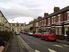
 Markham Street with terraced houses | |
 The Groves Location within North Yorkshire | |
| OS grid reference | SE606528 |
| Unitary authority |
|
| Ceremonial county | |
| Region | |
| Country | England |
| Sovereign state | United Kingdom |
| Post town | YORK |
| Postcode district | YO31 |
| Police | North Yorkshire |
| Fire | North Yorkshire |
| Ambulance | Yorkshire |
| UK Parliament | |
The district is near York Hospital and the city ring road. In the 19th century the area was populated by poor working-class inhabitants of long rows of back-to-back houses.[1] It consists largely of close-knit terraces, the majority of which date from the first two decades of the 20th century.[2] In the early 1960s, a large number of very small terraced houses were demolished to make way for flats and maisonettes which were built between Garden Street, Penleys Grove/Townend Street and Lowther Street;[3] this area has a residents' association.[4]
The Groves area contains a mixture of privately owned and rented properties, and council housing, and contains a number of students from York St John University. Lowther Street is the main area for local shopping, with an Indian restaurant and takeaway, Chinese takeaway, a small supermarket and a shop specialising in Polish food. In Penleys Grove Street there is a grocery shop.
Lowther Street is a busy route for traffic during rush hours, although a one-way system reduces traffic on this and Penleys Grove/Townend Street.
The Groves includes Park Grove Primary School,[5] the Young Groves centre, Door 84,[6] and St Thomas' Church.[7]
There is a police team which works with the community. In 2015 a ban on drinking alcohol on the streets was introduced to reduce anti-social behavior in the Groves.[8] The area crime rate is one of the lowest in York.
References
- Tillott, P. M., ed. (1961). "'Modern York: Social life, 1835-1900'". A History of the County of York: the City of York. British History Online. London: Victoria County History. pp. 286–289. Retrieved 1 November 2016.
- "The Expanding City". History of York: York Museums Trust. Retrieved 1 November 2016.
- "4 photos from the 1960s Groves demolitions in York". The Press. 20 January 2016. Retrieved 1 November 2016.
- "Map of the area covered by The Groves resident association" (pdf). City of York Council. Retrieved 1 November 2016.
- "Park Grove Primary School". Department of Education. Retrieved 1 November 2016.
- "Door 84". Door 84. Retrieved 1 November 2016.
- "St Thomas York". St Thomas with St Maurice. Retrieved 1 November 2016.
- Prest, Victoria (18 November 2015). "Street drinking ban for the Groves". The Press. Retrieved 1 November 2016.