Rural Municipality of Milton No. 292
The Rural Municipality of Milton No. 292 (2016 population: 241) is a rural municipality (RM) in the Canadian province of Saskatchewan within Census Division No. 13 and SARM Division No. 6. Located in the west-central portion of the province, it is adjacent to the Alberta boundary.
Milton No. 292 | |
|---|---|
| Rural Municipality of Milton No. 292 | |
 Location of the RM of Milton No. 292 in Saskatchewan | |
| Coordinates: 51.493°N 109.824°W[1] | |
| Country | Canada |
| Province | Saskatchewan |
| Census division | 13 |
| SARM division | 6 |
| Formed[2] | December 11, 1911 |
| Government | |
| • Reeve | David Bond |
| • Governing body | RM of Milton No. 292 Council |
| • Administrator | Robin Busby |
| • Office location | Marengo |
| Area (2016)[4] | |
| • Land | 658.64 km2 (254.30 sq mi) |
| Population (2016)[4] | |
| • Total | 241 |
| • Density | 0.4/km2 (1/sq mi) |
| Time zone | CST |
| • Summer (DST) | CST |
| Area code(s) | 306 and 639 |
History
The RM of Milton No. 292 incorporated as a rural municipality on December 11, 1911.[2] It was previously established as the Wirral Improvement District in 1905.
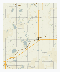
Geography
Communities and localities
The following urban municipalities are surrounded by the RM.
The following unincorporated communities are within the RM.
- Special service areas
- Localities
- Merid
Demographics
In the 2016 Census of Population conducted by Statistics Canada, the RM of Milton No. 292 recorded a population of 241 living in 109 of its 162 total private dwellings, a -22.8% change from its 2011 population of 312. With a land area of 658.64 km2 (254.30 sq mi), it had a population density of 0.4/km2 (0.9/sq mi) in 2016.[4]
In the 2011 Census of Population, the RM of Milton No. 292 recorded a population of 312, a 0.6% change from its 2006 population of 310. With a land area of 657.42 km2 (253.83 sq mi), it had a population density of 0.5/km2 (1.2/sq mi) in 2011.[7]
Government
The RM of Milton No. 292 is governed by an elected municipal council and an appointed administrator that meets on the second Wednesday of every month.[3] The reeve of the RM is David Bond while its administrator is Robin Busby.[3] The RM's office is located in Marengo.[3]
Transportation
- Rail[8]
- C.N.R. Saskatoon Calgary Branch—serves Flaxcombe, Marengo, Merid, Alsask, Sibbald
- Mantario Subdivision C.N.R—serves Kindersley, Alsask, Ardene
- Roads[9]
- Highway 7—serves Alsask
- Highway 44—serves Alsask
- Highway 317
- Francena Minerals Road, Saskatchewan
- Merid Road, Saskatchewan—comes close to Merid
References
- "Pre-packaged CSV files - CGN, Canada/Province/Territory (cgn_sk_csv_eng.zip)". Government of Canada. July 24, 2019. Retrieved May 23, 2020.
- "Rural Municipality Incorporations (Alphabetical)". Saskatchewan Ministry of Municipal Affairs. Archived from the original on April 21, 2011. Retrieved May 9, 2020.
- "Municipality Details: RM of Milton No. 292". Government of Saskatchewan. Retrieved May 21, 2020.
- "Population and dwelling counts, for Canada, provinces and territories, and census subdivisions (municipalities), 2016 and 2011 censuses – 100% data (Saskatchewan)". Statistics Canada. February 8, 2017. Retrieved May 1, 2020.
- "Saskatchewan Census Population" (PDF). Saskatchewan Bureau of Statistics. Archived from the original (PDF) on September 24, 2015. Retrieved May 9, 2020.
- "Saskatchewan Census Population". Saskatchewan Bureau of Statistics. Retrieved May 9, 2020.
- "Population and dwelling counts, for Canada, provinces and territories, and census subdivisions (municipalities), 2011 and 2006 censuses (Saskatchewan)". Statistics Canada. June 3, 2019. Retrieved May 1, 2020.
- Canadian Maps: January 1925 Waghorn's Guide. Post Offices in Man. Sask. Alta. and West Ontario.
- Eversoft Streets and Trips
Places adjacent to Rural Municipality of Milton No. 292 | |
|---|---|
| Towns | 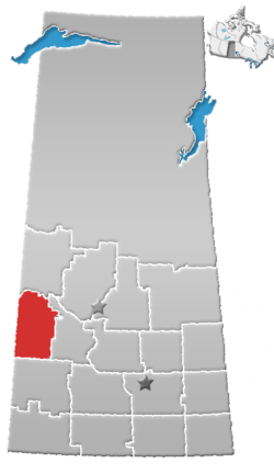 | ||||
|---|---|---|---|---|---|
| Villages | |||||
| Rural municipalities |
| ||||
| First Nations | |||||
| Indian reserves | |||||
| Unincorporated communities |
| ||||