Rural Municipality of Cambria No. 6
The Rural Municipality of Cambria No. 6 (2016 population: 309) is a rural municipality (RM) in the Canadian province of Saskatchewan within Census Division No. 2 and SARM Division No. 1. Located in the southeast portion of the province, it is adjacent to the United States border, neighbouring Divide County in North Dakota.
Cambria No. 6 | |
|---|---|
| Rural Municipality of Cambria No. 6 | |
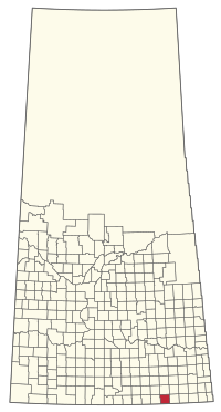 Location of the RM of Cambria No. 6 in Saskatchewan | |
| Coordinates: 49.129°N 103.427°W[1] | |
| Country | Canada |
| Province | Saskatchewan |
| Census division | 2 |
| SARM division | 1 |
| Federal riding | Souris--Moose Mountain |
| Provincial riding | Estevan |
| Formed[2] | December 13, 1909 |
| Government | |
| • Reeve | Darwin Daae |
| • Governing body | RM of Cambria No. 6 Council |
| • Administrator | Monica Kovach |
| • Office location | Torquay |
| Area (2016)[4] | |
| • Land | 814.14 km2 (314.34 sq mi) |
| Population (2016)[4] | |
| • Total | 309 |
| • Density | 0.4/km2 (1/sq mi) |
| Time zone | CST |
| • Summer (DST) | CST |
| Postal code | S0C 2L0 |
| Area code(s) | 306 and 639 |
History
The RM of Cambria No. 6 incorporated as a rural municipality on December 13, 1909.[2]
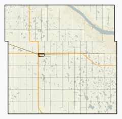
Geography
Communities and localities
The following urban municipalities are surrounded by the RM.
The following unincorporated hamlets are located within the RM.
- Localities
- Marienthal
- Outram
- Rafferty
Demographics
In the 2016 Census of Population conducted by Statistics Canada, the RM of Cambria No. 6 recorded a population of 309 living in 107 of its 115 total private dwellings, a 1.6% change from its 2011 population of 304. With a land area of 814.14 km2 (314.34 sq mi), it had a population density of 0.4/km2 (1.0/sq mi) in 2016.[4]
In the 2011 Census of Population, the RM of Cambria No. 6 recorded a population of 304, a 13.4% change from its 2006 population of 268. With a land area of 814.14 km2 (314.34 sq mi), it had a population density of 0.4/km2 (1.0/sq mi) in 2011.[7]
Government
The RM of Cambria No. 6 is governed by an elected municipal council and an appointed administrator that meets on the second Wednesday of every month.[3] The reeve of the RM is Darwin Daae while its administrator is Monica Kovach.[3] The RM's office is located in Torquay.[3]
References
- "Pre-packaged CSV files - CGN, Canada/Province/Territory (cgn_sk_csv_eng.zip)". Government of Canada. July 24, 2019. Retrieved May 23, 2020.
- "Rural Municipality Incorporations (Alphabetical)". Saskatchewan Ministry of Municipal Affairs. Archived from the original on April 21, 2011. Retrieved May 9, 2020.
- "Municipality Details: RM of Cambria No. 6". Government of Saskatchewan. Retrieved May 21, 2020.
- "Population and dwelling counts, for Canada, provinces and territories, and census subdivisions (municipalities), 2016 and 2011 censuses – 100% data (Saskatchewan)". Statistics Canada. February 8, 2017. Retrieved May 1, 2020.
- "Saskatchewan Census Population" (PDF). Saskatchewan Bureau of Statistics. Archived from the original (PDF) on September 24, 2015. Retrieved May 9, 2020.
- "Saskatchewan Census Population". Saskatchewan Bureau of Statistics. Retrieved May 9, 2020.
- "Population and dwelling counts, for Canada, provinces and territories, and census subdivisions (municipalities), 2011 and 2006 censuses (Saskatchewan)". Statistics Canada. June 3, 2019. Retrieved May 1, 2020.
Places adjacent to Rural Municipality of Cambria No. 6 | |
|---|---|
| Cities | 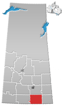 | ||||||
|---|---|---|---|---|---|---|---|
| Towns | |||||||
| Villages | |||||||
| Rural municipalities | |||||||
| First Nations | |||||||
| Indian reserves | |||||||
| Unincorporated communities |
| ||||||