Rural Municipality of Chesterfield No. 261
The Rural Municipality of Chesterfield No. 261 (2016 population: 481) is a rural municipality (RM) in the Canadian province of Saskatchewan within Census Division No. 8 and SARM Division No. 3.
Chesterfield No. 261 | |
|---|---|
| Rural Municipality of Chesterfield No. 261 | |
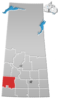
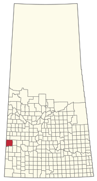 Location of the RM of Chesterfield No. 261 in Saskatchewan | |
| Coordinates: 51.017°N 109.663°W[1] | |
| Country | Canada |
| Province | Saskatchewan |
| Census division | 8 |
| SARM division | 3 |
| Formed[2] | December 9, 1912 |
| Government | |
| • Reeve | Karrie Derouin |
| • Governing body | RM of Chesterfield No. 261 Council |
| • Administrator | Tosha McCubbing |
| • Office location | Eatonia |
| Area (2016)[4] | |
| • Land | 1,943.29 km2 (750.31 sq mi) |
| Population (2016)[4] | |
| • Total | 481 |
| • Density | 0.2/km2 (0.5/sq mi) |
| Time zone | CST |
| • Summer (DST) | CST |
| Area code(s) | 306 and 639 |
History
The RM of Chesterfield No. 261 incorporated as a rural municipality on December 9, 1912.[2]
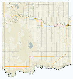
Geography
Communities and localities
The following urban municipalities are surrounded by the RM.
- Eatonia
- Mantario
The following unincorporated communities are within the RM.
- Organized hamlets
- Localities
- Cuthbert
- Eyre
Demographics
In the 2016 Census of Population conducted by Statistics Canada, the RM of Chesterfield No. 261 recorded a population of 481 living in 147 of its 165 total private dwellings, a 0.2% change from its 2011 population of 480. With a land area of 1,943.29 km2 (750.31 sq mi), it had a population density of 0.2/km2 (0.6/sq mi) in 2016.[4]
In the 2011 Census of Population, the RM of Chesterfield No. 261 recorded a population of 480, a -1% change from its 2006 population of 485. With a land area of 1,943.5 km2 (750.4 sq mi), it had a population density of 0.2/km2 (0.6/sq mi) in 2011.[7]
Attractions
- Buffalo Rubbing Stone Provincial Historic Site
- Estuary Ferry
- Great Wall of Saskatchewan
- Kindersley Plains Museum
- Kindersley Regional Park
- Motherwell Reservoir
- Prairie Elevator Museum - Acadia Valley, Alberta[8]
Government
The RM of Chesterfield No. 261 is governed by an elected municipal council and an appointed administrator that meets on the second Tuesday of every month.[3] The reeve of the RM is Karrie Derouin while its administrator is Tosha McCubbing.[3] The RM's office is located in Eatonia.[3]
Transportation
- Canadian National Railway
- Saskatchewan Highway 21
- Saskatchewan Highway 44
- Saskatchewan Highway 635
- Estuary Ferry
References
- "Pre-packaged CSV files - CGN, Canada/Province/Territory (cgn_sk_csv_eng.zip)". Government of Canada. July 24, 2019. Retrieved May 23, 2020.
- "Rural Municipality Incorporations (Alphabetical)". Saskatchewan Ministry of Municipal Affairs. Archived from the original on April 21, 2011. Retrieved May 9, 2020.
- "Municipality Details: RM of Chesterfield No. 261". Government of Saskatchewan. Retrieved May 21, 2020.
- "Population and dwelling counts, for Canada, provinces and territories, and census subdivisions (municipalities), 2016 and 2011 censuses – 100% data (Saskatchewan)". Statistics Canada. February 8, 2017. Retrieved May 1, 2020.
- "Saskatchewan Census Population" (PDF). Saskatchewan Bureau of Statistics. Archived from the original (PDF) on September 24, 2015. Retrieved May 9, 2020.
- "Saskatchewan Census Population". Saskatchewan Bureau of Statistics. Retrieved May 9, 2020.
- "Population and dwelling counts, for Canada, provinces and territories, and census subdivisions (municipalities), 2011 and 2006 censuses (Saskatchewan)". Statistics Canada. June 3, 2019. Retrieved May 1, 2020.
- Acadia Valley Elevator Museum
Places adjacent to Rural Municipality of Chesterfield No. 261 | |
|---|---|