Rural Municipality of Maple Bush No. 224
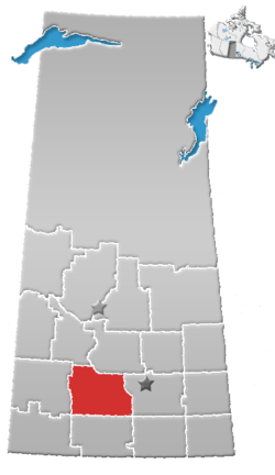
The Rural Municipality of Maple Bush No. 224 (2016 population: 192) is a rural municipality (RM) in the Canadian province of Saskatchewan within Census Division No. 7 and SARM Division No. 2. It is located in the southwest portion of the province.
Maple Bush No. 224 | |
|---|---|
| Rural Municipality of Maple Bush No. 224 | |
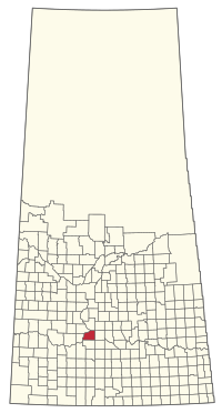 Location of the RM of Maple Bush No. 224 in Saskatchewan | |
| Coordinates: 50.981°N 106.772°W[1] | |
| Country | Canada |
| Province | Saskatchewan |
| Census division | 7 |
| SARM division | 2 |
| Formed[2] | December 13, 1909 |
| Government | |
| • Reeve | Maurice Bartzen |
| • Governing body | RM of Maple Bush No. 224 Council |
| • Administrator | JoAnne 'Rene' Wandler |
| • Office location | Riverhurst |
| Area (2016)[4] | |
| • Land | 811.95 km2 (313.50 sq mi) |
| Population (2016)[4] | |
| • Total | 192 |
| • Density | 0.2/km2 (0.5/sq mi) |
| Time zone | CST |
| • Summer (DST) | CST |
| Area code(s) | 306 and 639 |
History
The RM of Maple Bush No. 224 incorporated as a rural municipality on December 13, 1909.[2]
Geography
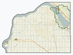
The RM is adjacent to Lake Diefenbaker and is home to Douglas Provincial Park.
Communities and localities
The following urban municipalities are surrounded by the RM.
- Elbow
- Riverhurst
- Mistusinne
The following unincorporated communities are within the RM.
- Localities
- Gilroy
- Grainland
- Lawson, dissolved as a village, December 31, 1985
Demographics
In the 2016 Census of Population conducted by Statistics Canada, the RM of Maple Bush No. 224 recorded a population of 192 living in 82 of its 164 total private dwellings, a 15% change from its 2011 population of 167. With a land area of 811.95 km2 (313.50 sq mi), it had a population density of 0.2/km2 (0.6/sq mi) in 2016.[4]
In the 2011 Census of Population, the RM of Maple Bush No. 224 recorded a population of 167, a -10.2% change from its 2006 population of 186. With a land area of 811.95 km2 (313.50 sq mi), it had a population density of 0.2/km2 (0.5/sq mi) in 2011.[7]
Attractions
- Douglas Provincial Park
- Elbow crater
- F.T. Museum
- Palliser Regional Park
- Qu'Appelle River Dam
- Riverhurst Ferry
Government
The RM of Maple Bush No. 224 is governed by an elected municipal council and an appointed administrator that meets on the second Wednesday of every month.[3] The reeve of the RM is Maurice Bartzen while its administrator is JoAnne 'Rene' Wandler.[3] The RM's office is located in Riverhurst.[3]
References
- "Pre-packaged CSV files - CGN, Canada/Province/Territory (cgn_sk_csv_eng.zip)". Government of Canada. July 24, 2019. Retrieved May 23, 2020.
- "Rural Municipality Incorporations (Alphabetical)". Saskatchewan Ministry of Municipal Affairs. Archived from the original on April 21, 2011. Retrieved May 9, 2020.
- "Municipality Details: RM of Maple Bush No. 224". Government of Saskatchewan. Retrieved May 21, 2020.
- "Population and dwelling counts, for Canada, provinces and territories, and census subdivisions (municipalities), 2016 and 2011 censuses – 100% data (Saskatchewan)". Statistics Canada. February 8, 2017. Retrieved May 1, 2020.
- "Saskatchewan Census Population" (PDF). Saskatchewan Bureau of Statistics. Archived from the original (PDF) on September 24, 2015. Retrieved May 9, 2020.
- "Saskatchewan Census Population". Saskatchewan Bureau of Statistics. Retrieved May 9, 2020.
- "Population and dwelling counts, for Canada, provinces and territories, and census subdivisions (municipalities), 2011 and 2006 censuses (Saskatchewan)". Statistics Canada. June 3, 2019. Retrieved May 1, 2020.