Rural Municipality of Deer Forks No. 232
The Rural Municipality of Deer Forks No. 232 (2016 population: 109) is a rural municipality (RM) in the Canadian province of Saskatchewan within Census Division No. 8 and SARM Division No. 3. Located in the southwest portion of the province, it is adjacent to the Alberta boundary, neighbouring Cypress County to the west.
Deer Forks No. 232 | |
|---|---|
| Rural Municipality of Deer Forks No. 232 | |
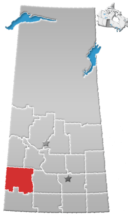
 Location of the RM of Deer Forks No. 232 in Saskatchewan | |
| Coordinates: 50.847°N 109.888°W[1] | |
| Country | Canada |
| Province | Saskatchewan |
| Census division | 8 |
| SARM division | 3 |
| Formed[2] | January 1, 1913 |
| Government | |
| • Reeve | Doug Smith |
| • Governing body | RM of Deer Forks No. 232 Council |
| • Administrator | Kim Lacelle |
| • Office location | Burstall |
| Area (2016)[4] | |
| • Land | 736.26 km2 (284.27 sq mi) |
| Population (2016)[4] | |
| • Total | 109 |
| • Density | 0.1/km2 (0.3/sq mi) |
| Time zone | CST |
| • Summer (DST) | CST |
| Postal code | S0N 0H0 |
| Area code(s) | 306 and 639 |
| Highway(s) | Highway 321 Highway 635 Highway 741 |
| Waterway(s) | South Saskatchewan River |
| Website | Official website |

History
The RM of Deer Forks No. 232 incorporated as a rural municipality on January 1, 1913.[2]
Geography
Communities and localities
The following urban municipalities are surrounded by the RM.
The following unincorporated communities are within the RM.
- Localities
- Estuary
- Gascoigne
Demographics
In the 2016 Census of Population conducted by Statistics Canada, the RM of Deer Forks No. 232 recorded a population of 109 living in 45 of its 56 total private dwellings, a -51.1% change from its 2011 population of 223. With a land area of 736.26 km2 (284.27 sq mi), it had a population density of 0.1/km2 (0.4/sq mi) in 2016.[4]
In the 2011 Census of Population, the RM of Deer Forks No. 232 recorded a population of 223, a 4.7% change from its 2006 population of 213. With a land area of 735.49 km2 (283.97 sq mi), it had a population density of 0.3/km2 (0.8/sq mi) in 2011.[7]
Government
The RM of Deer Forks No. 232 is governed by an elected municipal council and an appointed administrator that meets on the second Wednesday of every month.[3] The reeve of the RM is Doug Smith while its administrator is Kim Lacelle.[3] The RM's office is located in Burstall.[3]
References
- "Pre-packaged CSV files - CGN, Canada/Province/Territory (cgn_sk_csv_eng.zip)". Government of Canada. July 24, 2019. Retrieved May 23, 2020.
- "Rural Municipality Incorporations (Alphabetical)". Saskatchewan Ministry of Municipal Affairs. Archived from the original on April 21, 2011. Retrieved May 9, 2020.
- "Municipality Details: RM of Deer Forks No. 232". Government of Saskatchewan. Retrieved May 21, 2020.
- "Population and dwelling counts, for Canada, provinces and territories, and census subdivisions (municipalities), 2016 and 2011 censuses – 100% data (Saskatchewan)". Statistics Canada. February 8, 2017. Retrieved May 1, 2020.
- "Saskatchewan Census Population" (PDF). Saskatchewan Bureau of Statistics. Archived from the original (PDF) on September 24, 2015. Retrieved May 9, 2020.
- "Saskatchewan Census Population". Saskatchewan Bureau of Statistics. Retrieved May 9, 2020.
- "Population and dwelling counts, for Canada, provinces and territories, and census subdivisions (municipalities), 2011 and 2006 censuses (Saskatchewan)". Statistics Canada. June 3, 2019. Retrieved May 1, 2020.
External links
Places adjacent to Rural Municipality of Deer Forks No. 232 | ||||||||||
|---|---|---|---|---|---|---|---|---|---|---|
| ||||||||||