Rural Municipality of Manitou Lake No. 442
The Rural Municipality of Manitou Lake No. 442 (2016 population: 573) is a rural municipality (RM) in the Canadian province of Saskatchewan within Census Division No. 13 and SARM Division No. 6.
Manitou Lake No. 442 | |
|---|---|
| Rural Municipality of Manitou Lake No. 442 | |
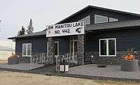 RM's office in Marsden | |
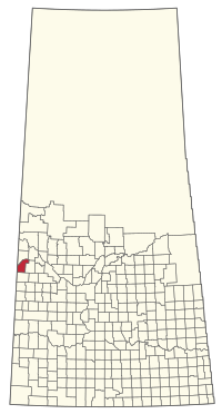 Location of the RM of Manitou Lake No. 442 in Saskatchewan | |
| Coordinates: 52.885°N 109.768°W[1] | |
| Country | Canada |
| Province | Saskatchewan |
| Census division | 13 |
| SARM division | 6 |
| Federal riding | Battlefords—Lloydminster |
| Provincial riding | Cut Knife-Turtleford |
| Formed[2] | December 12, 1910 |
| Government | |
| • Reeve | Ian Lamb |
| • Governing body | RM of Manitou Lake No. 442 Council |
| • Administrator | Joanne Loy |
| • Office location | Marsden |
| Area (2016)[4] | |
| • Land | 850.95 km2 (328.55 sq mi) |
| Population (2016)[4] | |
| • Total | 573 |
| • Density | 0.7/km2 (2/sq mi) |
| Time zone | CST |
| • Summer (DST) | CST |
| Postal code | S0M 1P0 |
| Area code(s) | 306 and 639 |
| Website | Official website |
History
The RM of Manitou Lake No. 442 incorporated as a rural municipality on December 12, 1910.[2] It takes its name from Manitou Lake, which Algonquian for "mysterious being."
In 1905, the first settlers came from Canadian regions, the British Isles and the United States. The area was known as the Manitou Lake District. In 1907-08 a post office was established in the home of Mr. Alex Wright, approximately one mile northeast of the present Marsden town site. The post office served the surrounding rural area. The Wrights named the post office 'Marsden'. One story recounts the name as originating from the birthplace of Mrs. Wright in Yorkshire, England; another reports it was named after the famous Marsden Rock near Newcastle, England. The adjacent area became known as the Marsden Rural Post Office District. Between 1919 and 1922, the post office was relocated one mile south to the RM office of Manitou Lake No. 442.
In 1905, the vast prairie land was covered with long grass referred to as 'prairie wool'. There were few trees or bluffs. The fertile black soil attracted many first settlers to the area and soon farms developed with sod and log homes. Farmers turned sod with horse and ox teams, sometimes using a walking plow (sulky) to prepare the ground for grain sowing. Grain was cut with binders, stooked, and threshed. Farmers hauled grain by wagon or horse-drawn sleigh to Zumbro and Artland. In the winter months, grain was hauled across the ice of Manitou Lake. Early settlers purchased groceries and supplies at Lashburn, Artland, or Chauvin, Alberta. A popular shopping method of the time was the Eaton's catalogue.
The settler's children first attended school in Learig, and in 1925 a four-room schoolhouse was built in the hamlet of Marsden.
Geography
Communities and localities
The following urban municipalities are surrounded by the RM.
The following unincorporated communities are within the RM.
- Localities
- Artland
- Unwin
Demographics
In the 2016 Census of Population conducted by Statistics Canada, the RM of Manitou Lake No. 442 recorded a population of 573 living in 209 of its 236 total private dwellings, a 4.8% change from its 2011 population of 547. With a land area of 850.95 km2 (328.55 sq mi), it had a population density of 0.7/km2 (1.7/sq mi) in 2016.[4]
In the 2011 Census of Population, the RM of Manitou Lake No. 442 recorded a population of 547, a -7.3% change from its 2006 population of 590. With a land area of 850.29 km2 (328.30 sq mi), it had a population density of 0.6/km2 (1.7/sq mi) in 2011.[7]
Economy
Agriculture, cattle and oil are primary industries for the population of 590 residents of the RM of Manitou Lake. Wheat, canola, barley, oats, peas and flax are typical crops in the area. The region is famous for its prize-winning purebred cattle that include Hereford, Charolais, Simmental, and Angus. Agriculture diversification is noticeable with specialty livestock production such as elk and bison.
The oil industry plays a significant role in the local economy. Oil wells and batteries in the countryside evidence heavy crude oil extraction in the region.
Attractions
Manitou Lake, in the Suffern Lake Regional Park, is located 4 miles (6.4 km) south and east of Marsden. The park facilities include campsites, showers, cookhouse, playgrounds, horseshoe pits, ball diamonds and a soccer field. A golf course is also located in the park.
Camping and guided trail rides through the Great Manito Sand Hills, one of Western Canada's most distinctive landscapes, are popular activities in the area.
Government
The RM of Manitou Lake No. 442 is governed by an elected municipal council and an appointed administrator that meets on the first Thursday after the first Tuesday of every month.[3] The reeve of the RM is Ian Lamb while its administrator is Joanne Loy.[3] The RM's office is located in Marsden.[3]
References
- "Pre-packaged CSV files - CGN, Canada/Province/Territory (cgn_sk_csv_eng.zip)". Government of Canada. July 24, 2019. Retrieved May 23, 2020.
- "Rural Municipality Incorporations (Alphabetical)". Saskatchewan Ministry of Municipal Affairs. Archived from the original on April 21, 2011. Retrieved May 9, 2020.
- "Municipality Details: RM of Manitou Lake No. 442". Government of Saskatchewan. Retrieved May 21, 2020.
- "Population and dwelling counts, for Canada, provinces and territories, and census subdivisions (municipalities), 2016 and 2011 censuses – 100% data (Saskatchewan)". Statistics Canada. February 8, 2017. Retrieved May 1, 2020.
- "Saskatchewan Census Population" (PDF). Saskatchewan Bureau of Statistics. Archived from the original (PDF) on September 24, 2015. Retrieved May 9, 2020.
- "Saskatchewan Census Population". Saskatchewan Bureau of Statistics. Retrieved May 9, 2020.
- "Population and dwelling counts, for Canada, provinces and territories, and census subdivisions (municipalities), 2011 and 2006 censuses (Saskatchewan)". Statistics Canada. June 3, 2019. Retrieved May 1, 2020.
| Towns | 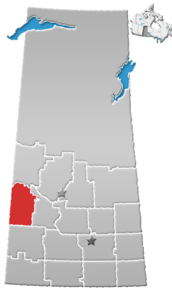 | ||||
|---|---|---|---|---|---|
| Villages | |||||
| Rural municipalities |
| ||||
| First Nations | |||||
| Indian reserves | |||||
| Unincorporated communities |
| ||||