Brownlee, Saskatchewan
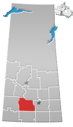
Brownlee (2016 population: 55) is a village in the Canadian province of Saskatchewan within the Rural Municipality of Eyebrow No. 193 and Census Division No. 7. The village is located approximately 58 km northwest of the City of Moose Jaw on Highway 42.
Brownlee | |
|---|---|
| Village of Brownlee | |
 Location of Brownlee in Saskatchewan  Brownlee, Saskatchewan (Canada) | |
| Coordinates: 50.739°N 106.015°W | |
| Country | |
| Province | |
| Region | South-central |
| Census division | 7 |
| Rural Municipality | Eyebrow No. 193 |
| Incorporated (Village) | August 11, 1908 |
| Government | |
| • Type | Municipal |
| • Governing body | Brownlee Village Council |
| • Mayor | Lyle Swanson |
| • Administrator | Jackie Leggott |
| Area | |
| • Total | 2.42 km2 (0.93 sq mi) |
| Population (2016) | |
| • Total | 104 |
| • Density | 20.7/km2 (54/sq mi) |
| Time zone | UTC-6 (CST) |
| Postal code | S0H 0M0 |
| Area code(s) | 306 |
| Highways | |
| Railways | Canadian Pacific Railway (Abandoned) |
| [1][2][3][4] | |
History
Brownlee incorporated as a village on December 29, 1908.[5]
Demographics
In the 2016 Census of Population conducted by Statistics Canada, the Village of Brownlee recorded a population of 55 living in 26 of its 29 total private dwellings, a 9.1% change from its 2011 population of 50. With a land area of 2.42 km2 (0.93 sq mi), it had a population density of 22.7/km2 (58.9/sq mi) in 2016.[8]
In the 2011 Census of Population, the Village of Brownlee recorded a population of 50, a 0% change from its 2006 population of 50. With a land area of 2.42 km2 (0.93 sq mi), it had a population density of 20.7/km2 (53.5/sq mi) in 2011.[9]
See also
- List of communities in Saskatchewan
- Villages of Saskatchewan
References
- National Archives, Archivia Net, Post Offices and Postmasters, archived from the original on 2006-10-06
- Government of Saskatchewan, MRD Home, Municipal Directory System, archived from the original on November 21, 2008
- Canadian Textiles Institute. (2005), CTI Determine your provincial constituency, archived from the original on 2007-09-11
- Commissioner of Canada Elections, Chief Electoral Officer of Canada (2005), Elections Canada On-line, archived from the original on 2007-04-21
- "Urban Municipality Incorporations". Saskatchewan Ministry of Government Relations. Archived from the original on October 15, 2014. Retrieved June 1, 2020.
- "Saskatchewan Census Population" (PDF). Saskatchewan Bureau of Statistics. Archived from the original (PDF) on September 24, 2015. Retrieved May 31, 2020.
- "Saskatchewan Census Population". Saskatchewan Bureau of Statistics. Retrieved May 31, 2020.
- "Population and dwelling counts, for Canada, provinces and territories, and census subdivisions (municipalities), 2016 and 2011 censuses – 100% data (Saskatchewan)". Statistics Canada. February 8, 2017. Retrieved May 30, 2020.
- "Population and dwelling counts, for Canada, provinces and territories, and census subdivisions (municipalities), 2011 and 2006 censuses (Saskatchewan)". Statistics Canada. June 3, 2019. Retrieved May 30, 2020.
Places adjacent to Brownlee, Saskatchewan | ||||||||||
|---|---|---|---|---|---|---|---|---|---|---|
| ||||||||||