Local-level governments of Papua New Guinea
This page is a list of local-level governments (LLGs) of Papua New Guinea. There are 326 LLGs comprising 6,112 wards as of 2018.[1]
 |
|---|
| This article is part of a series on the politics and government of Papua New Guinea |
|
Executive |
|
Legislature
|
|
Judiciary
|
|
Administrative divisions |
|
|
|
Related topics
|
Note: LLG names with slashes (/) are listed with dashes (-) due to technical limitations on previous versions of the Wikipedia software.
Administrative divisions
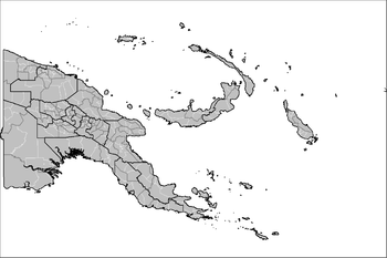
On the highest level, Papua New Guinea is divided into 4 regions, which are Highlands, Islands, Momase, and Southern regions.
Below, Papua New Guinea has 22 province-level divisions: 20 integrated provinces, the autonomous province of North Solomons (Bougainville) and the National Capital District.
Each province has one or more districts, and each district has one or more local-level government (LLG) areas. For census purposes, the LLG areas are subdivided into wards and those into census units.[2]
Wards typically consist of a few hundred to a few thousand individuals, and are the lowest level of government administration under local-level governments (LLGs). Wards are further divided into census units (CU).
List of local-level governments by region and province
Chimbu Province
| District | District Capital | LLG Name |
|---|---|---|
| Chuave District | Chuave | Chuave Rural |
| Elimbari Rural | ||
| Siane Rural | ||
| Gumine District | Gumine | Bomai-Gumai Rural |
| Gumine Rural | ||
| Mount Digine Rural | ||
| Karimui-Nomane District | Karimui | Karimui Rural |
| Nomane Rural | ||
| Salt Rural | ||
| Kerowagi District | Kerowagi | Gena-Waugla Rural |
| Upper-Lower Koronigl Rural | ||
| Kerowagi Urban | ||
| Kup Rural | ||
| Kundiawa-Gembogl District | Kundiawa | Kundiawa Urban |
| Mitnande Rural (Mount Wilhelm Rural) | ||
| Niglkande Rural | ||
| Waiye Rural | ||
| Sina Sina-Yonggomugl District | Yonggomugl | Tabare Rural (Sinasina) |
| Suai Rural (Suwai) | ||
| Yonggomugl Rural |
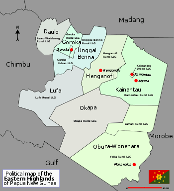
Eastern Highlands Province
Enga Province
Southern Highlands Province
Western Highlands Province
| District | District Capital | LLG Name |
|---|---|---|
| Dei District | Dei | Dei Rural (Muglamp) |
| Kotna Rural | ||
| Mount Hagen District | Mount Hagen | Mount Hagen Rural |
| Mount Hagen Urban | ||
| Mul-Baiyer District | Baiyer | Baiyer Rural |
| Lumusa Rural | ||
| Mul Rural | ||
| Tambul-Nebilyer District | Tambul | Mount Giluwe Rural |
| Nebilyer Rural |
Hela Province
| District | District Capital | LLG Name |
|---|---|---|
| Komo-Magarima District | Magarima | Hulia Rural |
| Komo Rural | ||
| Upper Wage Rural | ||
| Lower Wage Rural | ||
| Koroba-Kopiago District | Kopiago | Awi-Pori Rural |
| Lake Kopiago Rural | ||
| North Koroba Rural | ||
| South Koroba Rural | ||
| Tari-Pori District | Tari | Hayapuga Rural |
| Tagali Rural | ||
| Tari Urban | ||
| Tebi Rural |
Jiwaka Province
| District | District Capital | LLG Name |
|---|---|---|
| Anglimp-South Waghi District | Minj | Anglimp Rural |
| South Waghi Rural | ||
| Jimi District | Tabibuga | Jimi Rural |
| Kol Rural | ||
| North Waghi District | Banz | North Waghi Rural |
| Nondugl Rural |
East New Britain Province
Manus Province
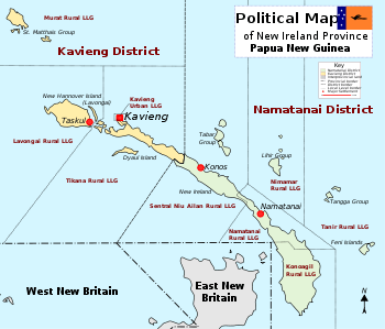
New Ireland Province
West New Britain Province
Autonomous Region of Bougainville
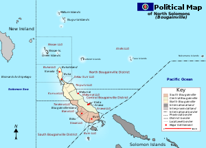
| District | District Capital | LLG Name |
|---|---|---|
| Central Bougainville District | Arawa-Kieta | Arawa Rural |
| Wakunai Rural | ||
| North Bougainville District | Buka | Atolls Rural |
| Buka Rural | ||
| Kunua Rural | ||
| Nissan Rural | ||
| Selau-Suir Rural | ||
| Tinputz Rural | ||
| South Bougainville District | Buin | Bana Rural |
| Buin Rural | ||
| Siwai Rural | ||
| Torokina Rural | ||
East Sepik Province
Madang Province
Morobe Province
Sandaun (West Sepik) Province
Central Province
Gulf Province
Milne Bay Province
| District | District Capital | LLG Name |
|---|---|---|
| Alotau District | Alotau | Alotau Urban |
| Daga Rural | ||
| Huhu Rural | ||
| Makamaka Rural | ||
| Maramatana Rural | ||
| Suau Rural | ||
| Weraura Rural | ||
| Esa'ala District | Esa'ala | Dobu Rural |
| Duau Rural | ||
| West Ferguson | ||
| Kiriwini-Goodenough District | Kiriwina | Goodenough Island Rural |
| Kiriwina Rural | ||
| Samarai-Murua District | Murua | Bwanabwana Rural |
| Louisiade Rural | ||
| Murua Rural | ||
| Yaleyamba Rural |
Oro (Northern) Province
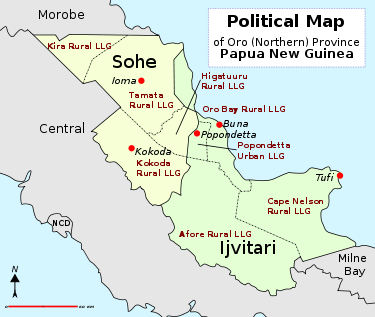
| District | District Capital | LLG Name |
|---|---|---|
| Ijivitari District | Popondetta | Afore Rural |
| Oro Bay Rural | ||
| Popendetta Urban | ||
| Safia Urban | ||
| Tufi Rural (Cape Nelson) | ||
| Sohe District | Kokoda | Higaturu Rural |
| Kira Rural | ||
| Kokoda Rural | ||
| Tamata Rural |
Western (Fly) Province
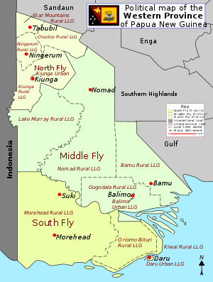
| District | District Capital | LLG Name |
|---|---|---|
| North Fly District | Kiunga | Kiunga Rural |
| Kiunga Urban | ||
| Ningerum Rural | ||
| Olsobip Rural | ||
| Star Mountains Rural | ||
| Middle Fly District | Balimo | Balimo Urban |
| Bamu Rural | ||
| Gogodala Rural | ||
| Lake Murray Rural | ||
| Nomad Rural | ||
| South Fly District | Daru | Daru Urban |
| Kiwai Rural | ||
| Morehead Rural | ||
| Oriomo-Bituri Rural |
National Capital District
| District | District Capital | LLG Name |
|---|---|---|
| National Capital District | Port Moresby | Gerehu Urban |
| Waigani-University Urban | ||
| Tokarara-Hohola Urban | ||
| Gordons-Saraga Urban | ||
| Boroko-Korobosea Urban | ||
| Kilakila-Kaugere Urban | ||
| Town-Hanuabada Urban | ||
| Laloki-Napanapa Urban | ||
| Bomana Urban |
Demographics and postal codes
The following is a list of local-level government areas sorted by postal code. Postal codes, all prefixed with the country code PG, begin with two-digit provincial codes, followed by two-digit district codes, and finally two-digit LLG codes.[1]
See also
References
- OCHA FISS (2018). "Papua New Guinea administrative level 0, 1, 2, and 3 population statistics and gazetteer". Humanitarian Data Exchange. 1.31.9.
- "Pacific Regional Statistics - Secretariat of the Pacific Community". www.spc.int. Retrieved 7 April 2018.
- "Census Figures by Wards - Highlands Region". www.nso.gov.pg. 2011 National Population and Housing Census: Ward Population Profile. Port Moresby: National Statistical Office, Papua New Guinea. 2014.
- "Census Figures by Wards - Islands Region". www.nso.gov.pg. 2011 National Population and Housing Census: Ward Population Profile. Port Moresby: National Statistical Office, Papua New Guinea. 2014.
- "Census Figures by Wards - Momase Region". www.nso.gov.pg. 2011 National Population and Housing Census: Ward Population Profile. Port Moresby: National Statistical Office, Papua New Guinea. 2014.
- "Census Figures by Wards - Southern Region". www.nso.gov.pg. 2011 National Population and Housing Census: Ward Population Profile. Port Moresby: National Statistical Office, Papua New Guinea. 2014.
- "Final Figures". www.nso.gov.pg. 2011 National Population and Housing Census: Ward Population Profile. Port Moresby: National Statistical Office, Papua New Guinea. 2014.
- LLG boundary maps by Province (National Research Institute of Papua New Guinea)
- United Nations in Papua New Guinea (2018). "Papua New Guinea - Postal codes and Coordinates". Humanitarian Data Exchange. 1.31.9.
- OCHA FISS (2018). "Papua New Guinea administrative level 0, 1, 2, and 3 population statistics and gazetteer". Humanitarian Data Exchange. 1.31.9.
- United Nations in Papua New Guinea (2018). "Papua New Guinea Village Coordinates Lookup". Humanitarian Data Exchange. 1.31.9.
External links
- National Statistical Office, Papua New Guinea (2011 National Population and Housing Census documents)
- Mapping Application with a lot of detail down to the LLG level
- Local Level Government list – Inter Government relations department of PNG
- PNG Business Directory
- List of District Capitals
- Schedule of Polling for 2007 election – PNG Electoral Commission (document contains LLG details)
- List of LLGs by Province, with Presidents or Mayors