Tikana Rural LLG
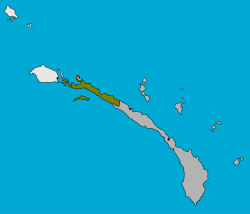
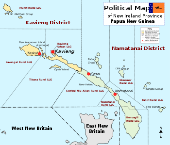
Tikana Rural LLG is a local government area in New Ireland Province, Papua New Guinea. The LLG administers the northern section of the island of New Ireland, as well as Djaul Island and some Tigak islands in the strait between New Ireland and New Hanover.
Tikana Rural LLG | |
|---|---|
 | |
| Country | Papua New Guinea |
| Province | New Ireland Province |
| Time zone | UTC+10 (AEST) |

District map of New Ireland Province
The LLG is located in Kavieng District and the LLG headquarters is Kavieng, although Kavieng has its own urban LLG.
Tikana is a portmanteau word derived from the names of the three language areas that make up the LLG: Tigak, Kara and Nalik. Population is 33,222 (PNG Census 2011).
The Kuot language is spoken in the southern part of the LLG.[1][2]
The LLG president is Ken Bart.
Wards
- 01. Enang
- 02. Nonovaul
- 03. Panapai
- 04. Kaselok
- 05. Bagatare
- 06. Lokono
- 07. Ngavalus
- 08. Paruai
- 09. Lemakot
- 10. Panamana
- 11. Madina
- 12. Kafkaf (Kuot language speakers)[2][1]:29
- 13. Namasalang
- 14. Belifu
- 15. Pangeifua
- 16. Lamusmus
- 17. Leon
- 18. Lapai
- 83. Lakurumau Estate
gollark: Oh, it did randomly break.
gollark: But it doesn't implement the full protocol despite years of development.
gollark: I run Dendrite, assuming it didn't randomly break at some point (I haven't checked), and that at least seems to have been improved to not use that much RAM *most* of the time.
gollark: I also don't like that Matrix is an unusably complex protocol requiring giant and resource-hungry server software even for small installs.
gollark: All the federated chat things seem to be doomed to never get any use because something something network effects and somewhat less convenient user experience.
References
- Lindström, Eva. 2002. Topics in the Grammar of Kuot. Ph.D. dissertation, Stockholm University.
- United Nations in Papua New Guinea (2018). "Papua New Guinea Village Coordinates Lookup". Humanitarian Data Exchange. 1.31.9.
- "Census Figures by Wards - Islands Region". www.nso.gov.pg. 2011 National Population and Housing Census: Ward Population Profile. Port Moresby: National Statistical Office, Papua New Guinea. 2014.
- "Final Figures". www.nso.gov.pg. 2011 National Population and Housing Census: Ward Population Profile. Port Moresby: National Statistical Office, Papua New Guinea. 2014.
- OCHA FISS (2018). "Papua New Guinea administrative level 0, 1, 2, and 3 population statistics and gazetteer". Humanitarian Data Exchange. 1.31.9.
- United Nations in Papua New Guinea (2018). "Papua New Guinea Village Coordinates Lookup". Humanitarian Data Exchange. 1.31.9.
This article is issued from Wikipedia. The text is licensed under Creative Commons - Attribution - Sharealike. Additional terms may apply for the media files.