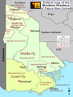
Nomad Rural LLG
Morehead Rural LLG is a local-level government (LLG) of Western Province, Papua New Guinea.[1][2]
Nomad Rural LLG | |
|---|---|
 District map of Western Province | |
| Country | Papua New Guinea |
| Province | Western Province |
| Time zone | UTC+10 (AEST) |
Wards
- 01. Igimi
- 02. Mougulu
- 03. Kofabi
- 04. Adumari
- 05. Ugubi
- 06. Sefalobi
- 07. Igibia
- 08. Sedado
- 09. Ugulubabi
- 10. Sadubi
- 11. Fuma
- 12. Hafemi
- 13. Yulabi
- 14. Suabi
- 16. Beredina
- 17. Pipila
- 18. Wakela
- 19. Egebila
- 20. Honabi
- 21. Udugombi
- 22. Kukudobi
- 23. Sirigubi
- 24. Mabomanibi
- 25. Wasubi
- 26. Bubusmabi
- 27. Aeyedubi
- 28. Tinahai
- 29. Sinabi
- 30. Wanbi
- 31. Kwobi
- 32. Testabi
- 33. Kuda
- 34. Debepari
- 35. Sokabi
- 36. Honinabi
- 37. Nomad Station
- 38. Dodomona
- 39. Filisato/Banisato
gollark: Because it's good?
gollark: How will you guess code?
gollark: Lyricly, you can't even make minoteaur.
gollark: I also trained a neural network to do code guessing, but it isn't very good and keeps insisting it's amazing about 6 days in advance.
gollark: WhatsApp? Really?
References
- "Census Figures by Wards - Southern Region". www.nso.gov.pg. 2011 National Population and Housing Census: Ward Population Profile. Port Moresby: National Statistical Office, Papua New Guinea. 2014.
- "Final Figures". www.nso.gov.pg. 2011 National Population and Housing Census: Ward Population Profile. Port Moresby: National Statistical Office, Papua New Guinea. 2014.
- OCHA FISS (2018). "Papua New Guinea administrative level 0, 1, 2, and 3 population statistics and gazetteer". Humanitarian Data Exchange. 1.31.9.
- United Nations in Papua New Guinea (2018). "Papua New Guinea Village Coordinates Lookup". Humanitarian Data Exchange. 1.31.9.
This article is issued from Wikipedia. The text is licensed under Creative Commons - Attribution - Sharealike. Additional terms may apply for the media files.