Thuir
Thuir (Catalan Tuïr) is a commune in the Pyrénées-Orientales department in southern France.
Thuir Tuïr | |
|---|---|
.jpg) The town hall in Thuir | |
.svg.png) Coat of arms | |
Location of Thuir 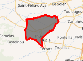
| |
 Thuir  Thuir | |
| Coordinates: 42°37′59″N 2°45′26″E | |
| Country | France |
| Region | Occitanie |
| Department | Pyrénées-Orientales |
| Arrondissement | Céret |
| Canton | Les Aspres |
| Intercommunality | Aspres |
| Government | |
| • Mayor (2008–2014) | René Olive |
| Area 1 | 19.90 km2 (7.68 sq mi) |
| Population (2017-01-01)[1] | 7,635 |
| • Density | 380/km2 (990/sq mi) |
| Time zone | UTC+01:00 (CET) |
| • Summer (DST) | UTC+02:00 (CEST) |
| INSEE/Postal code | 66210 /66300 |
| Elevation | 78–243 m (256–797 ft) (avg. 99 m or 325 ft) |
| 1 French Land Register data, which excludes lakes, ponds, glaciers > 1 km2 (0.386 sq mi or 247 acres) and river estuaries. | |
Geography
Thuir is located southwest of Perpignan, in the canton of Les Aspres and in the arrondissement of Perpignan. It is situated in a plain between the natural zones of the Aspres and the Riberal.
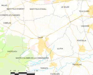
Map of Thuir and its surrounding communes
Population
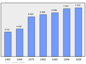
Population 1962-2008
gollark: Back when I was trying to get 50 comment karma for my bot it wasn't very hard.
gollark: I'm pretty sure there are lists available, yes.
gollark: Most of the time you want to hold an arbitrary amount of items, hence vectors.
gollark: Lots of languages muddle arrays and vectors a bit.
gollark: Minecraft java edition is... written in it.
External links
![]()
| Authority control |
|
|---|
This article is issued from Wikipedia. The text is licensed under Creative Commons - Attribution - Sharealike. Additional terms may apply for the media files.