Terrats
Terrats is a commune in the Pyrénées-Orientales department in southern France.
Terrats | |
|---|---|
.jpg) The town hall in Terrats | |
Location of Terrats 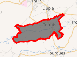
| |
 Terrats  Terrats | |
| Coordinates: 42°36′36″N 2°46′20″E | |
| Country | France |
| Region | Occitanie |
| Department | Pyrénées-Orientales |
| Arrondissement | Céret |
| Canton | Les Aspres |
| Intercommunality | Aspres |
| Government | |
| • Mayor (2001–2008) | Erick Brisse |
| Area 1 | 7.32 km2 (2.83 sq mi) |
| Population (2017-01-01)[1] | 640 |
| • Density | 87/km2 (230/sq mi) |
| Time zone | UTC+01:00 (CET) |
| • Summer (DST) | UTC+02:00 (CEST) |
| INSEE/Postal code | 66207 /66300 |
| Elevation | 101–230 m (331–755 ft) (avg. 138 m or 453 ft) |
| 1 French Land Register data, which excludes lakes, ponds, glaciers > 1 km2 (0.386 sq mi or 247 acres) and river estuaries. | |
Geography
Terrats is located in the canton of Les Aspres and in the arrondissement of Perpignan.
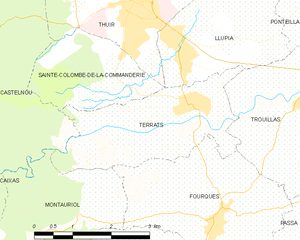
Map of Terrats and its surrounding communes
Population
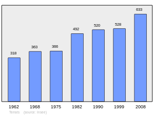
Population 1962-2008
gollark: "why yes, of course I'm going to use 100KB of JavaScript to reimplement native browser features but worse"
gollark: "hmm yes I will include this 1MB stock image for my 10KB of text making up this article"
gollark: To be fair, the modern web is awful.
gollark: I've directly imaged 99.7% of your neural pathways via inelastic X-ray scattering.
gollark: Incorrect.
References
- "Populations légales 2017". INSEE. Retrieved 6 January 2020.
| Wikimedia Commons has media related to Terrats. |
| Authority control |
|
|---|
This article is issued from Wikipedia. The text is licensed under Creative Commons - Attribution - Sharealike. Additional terms may apply for the media files.