Llauro
Llauro (Catalan: Llauró) is a commune in the Pyrénées-Orientales department in southern France.
Llauro Llauró | |
|---|---|
 Llauro | |
.svg.png) Coat of arms | |
Location of Llauro 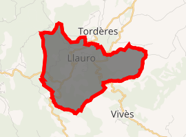
| |
 Llauro  Llauro | |
| Coordinates: 42°33′02″N 2°44′40″E | |
| Country | France |
| Region | Occitanie |
| Department | Pyrénées-Orientales |
| Arrondissement | Céret |
| Canton | Les Aspres |
| Intercommunality | Aspres |
| Government | |
| • Mayor (2008–2014) | Roger Tourné |
| Area 1 | 8.34 km2 (3.22 sq mi) |
| Population (2017-01-01)[1] | 317 |
| • Density | 38/km2 (98/sq mi) |
| Time zone | UTC+01:00 (CET) |
| • Summer (DST) | UTC+02:00 (CEST) |
| INSEE/Postal code | 66099 /66300 |
| Elevation | 174–511 m (571–1,677 ft) (avg. 138 m or 453 ft) |
| 1 French Land Register data, which excludes lakes, ponds, glaciers > 1 km2 (0.386 sq mi or 247 acres) and river estuaries. | |
Geography
Llauro is located in the canton of Les Aspres and in the arrondissement of Perpignan.
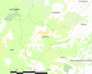
Map of Llauro and its surrounding communes
Population
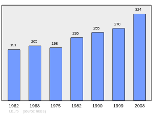
Population 1962-2008
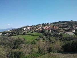
Sites of interest
- Saint Martin church
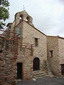
Saint Martin church
gollark: Anyway, good password hashing algorithms are designed to be hard to parallelize, and to require large amounts of memory, so that they're hard to implement on FPGAs/ASICs/GPUs and run fastest on general-purpose CPU hardware (this is what your server has).
gollark: Basically!
gollark: Also a salt per password.
gollark: Basically, with passwords, you want a hashing algorithm which is somewhat slow so that it can't be bruteforced.
gollark: SHA256/MD5/etc are not acceptable password hashing algorithms. This is because they are very fast.
References
- "Populations légales 2017". INSEE. Retrieved 6 January 2020.
| Wikimedia Commons has media related to Llauro. |
| Authority control |
|
|---|
This article is issued from Wikipedia. The text is licensed under Creative Commons - Attribution - Sharealike. Additional terms may apply for the media files.