La Llagonne
La Llagonne (Catalan: La Llaguna) is a commune in the Pyrénées-Orientales department in southern France.
La Llagonne La Llaguna | |
|---|---|
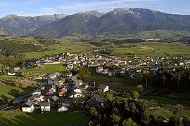 An aerial view of La Llagonne | |
 Coat of arms | |
Location of La Llagonne 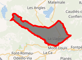
| |
 La Llagonne  La Llagonne | |
| Coordinates: 42°31′38″N 2°07′18″E | |
| Country | France |
| Region | Occitanie |
| Department | Pyrénées-Orientales |
| Arrondissement | Prades |
| Canton | Les Pyrénées catalanes |
| Intercommunality | Capcir Haut-Conflent |
| Government | |
| • Mayor (2014–2020) | Jean-Pierre Astruch |
| Area 1 | 23.09 km2 (8.92 sq mi) |
| Population (2017-01-01)[1] | 219 |
| • Density | 9.5/km2 (25/sq mi) |
| Time zone | UTC+01:00 (CET) |
| • Summer (DST) | UTC+02:00 (CEST) |
| INSEE/Postal code | 66098 /66210 |
| Elevation | 1,546–2,196 m (5,072–7,205 ft) (avg. 1,657 m or 5,436 ft) |
| 1 French Land Register data, which excludes lakes, ponds, glaciers > 1 km2 (0.386 sq mi or 247 acres) and river estuaries. | |
Geography
La Llagonne is located in the canton of Les Pyrénées catalanes and in the arrondissement of Prades.
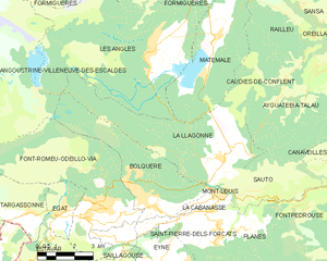
Map of La Llagonne and its surrounding communes
Population
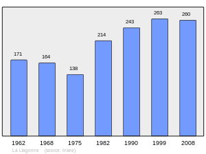
Population 1962-2008
gollark: In a sane system it would make more sense to just make the courses a year longer to cover background material instead of forcing people through 4 years of extremely expensive education.
gollark: Having to do 4 years of schooling before medicine-specific stuff seems dubiously useful.
gollark: Medical degrees here are like regular undergraduate ones but I think somewhat more government-specified and a bit longer.
gollark: Memorizing vast amounts of random information is probably less important now you can look it up quickly too.
gollark: Some tests are apparently okay. But I would be fine with a doctor who didn't do well on standardized testing but did fine otherwise.
References
- "Populations légales 2017". INSEE. Retrieved 6 January 2020.
- Cárdenas, Fabricio (2014). 66 petites histoires du Pays Catalan [66 Little Stories of Catalan Country] (in French). Perpignan: Ultima Necat. ISBN 978-2-36771-006-8. OCLC 893847466.
| Wikimedia Commons has media related to La Llagonne. |
| Authority control |
|---|
This article is issued from Wikipedia. The text is licensed under Creative Commons - Attribution - Sharealike. Additional terms may apply for the media files.