Passa, Pyrénées-Orientales
Passa (Catalan: Paçà) is a commune in the Pyrénées-Orientales department in southern France.
Passa Paçà | |
|---|---|
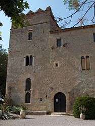 The Monastir del Camp, in Passa | |
 Coat of arms | |
Location of Passa 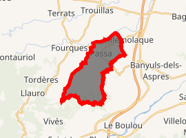
| |
 Passa  Passa | |
| Coordinates: 42°34′44″N 2°48′44″E | |
| Country | France |
| Region | Occitanie |
| Department | Pyrénées-Orientales |
| Arrondissement | Céret |
| Canton | Les Aspres |
| Intercommunality | Aspres |
| Government | |
| • Mayor (2008–2014) | Patrick Bellegarde |
| Area 1 | 13.47 km2 (5.20 sq mi) |
| Population (2017-01-01)[1] | 820 |
| • Density | 61/km2 (160/sq mi) |
| Time zone | UTC+01:00 (CET) |
| • Summer (DST) | UTC+02:00 (CEST) |
| INSEE/Postal code | 66134 /66300 |
| Elevation | 85–204 m (279–669 ft) (avg. 138 m or 453 ft) |
| 1 French Land Register data, which excludes lakes, ponds, glaciers > 1 km2 (0.386 sq mi or 247 acres) and river estuaries. | |
Geography
Passa is located in the canton of Les Aspres and in the arrondissement of Perpignan.
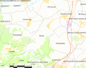
Map of Passa and its surrounding communes
Population
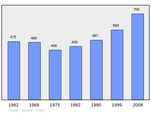
Population 1962-2008
gollark: If you make mistakes, crabs emerge from your keyboard and bite you.
gollark: Resource Initialization Is Redundant?
gollark: Also, bulls are not in fact real.
gollark: * SCB (Secure, Contain, BEES AÅAAAÅAAA)
gollark: And/or bee summoning rituals.
References
- "Populations légales 2017". INSEE. Retrieved 6 January 2020.
| Wikimedia Commons has media related to Passa. |
This article is issued from Wikipedia. The text is licensed under Creative Commons - Attribution - Sharealike. Additional terms may apply for the media files.